China firmly opposes the United States' signing of the arm-aid bill which contains negative articles on China, said Lin Jian, spokesman of the Ministry of Foreign Affairs of China in Beijing on Monday.
Speaking at a regular press conference, Lin said China has lodged serious representations to the U.S. over the package and urged the U.S. side not to implement those negative articles.
"This package gravely infringes upon China's sovereignty. It includes large military aid to Taiwan, which seriously violates the one-China principle and the three China-US joint communiques, and sends a seriously wrong signal to 'Taiwan independence' separatist forces. The legislation undermines the principles of market economy and fair competition by wantonly going after other countries' companies in the name of 'national security,' which once again reveals the US's hegemonic and bullying nature. It advocates sanctions on China in disregard of the huge amount of work China has done to help the US address its fentanyl crisis. The legislation also threatens to impose unilateral sanctions and long-arm jurisdiction over normal economic and trade exchanges between China and Iran under the framework of international law, which creates serious obstacles for China-US cooperation in relevant areas," said Lin.
"We urge the US to respect China's core interests and major concerns, and not to implement these negative articles concerning China. Otherwise China will take strong and resolute measures to safeguard our sovereignty, security and development interests," he said.

China urges US not to implement negative articles concerning China: spokesman
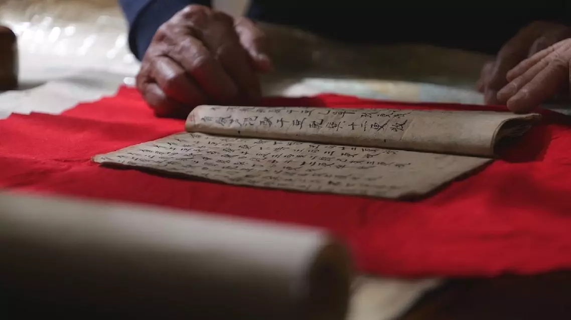
Centuries-old maps handed down to fishermen by their ancestors in Tanmen Township of China's southernmost Hainan Province provides compelling evidence to China's sovereignty over the South China Sea, according to a China Global Television Network (CGTN) documentary released on Friday.
Like many people in Tanmen, Lu Jiabing was born into a fishermen' family going back generations. What distinguishes Lu's family is a treasured family heirloom -- a booklet used to navigate the South China Sea which Tanmen residents call "Genglubu", meaning "Route Map."
Each family's Genglubu is different from another. Passed down through successive generations, the documents embody the Tanmen fishermen's adventurer spirits, and have become an important basis for China's territorial rights in the South China Sea. "I'm not sure when this Genglubu was written. Anyway, it's been passed down from generation to generation, and I'm the sixth in line to inherit it. We used it along with a compass at sea. The needle of the compass points toward south and north. 'Zi' refers to north and 'Wu' to south. There are 24 squares, each containing one character. One square represents 15 degrees, and there are 360 degrees in total," Lu told CGTN.
Out on the vast ocean, the compass and Genglubu have forged new routes at sea for the fishermen over the past centuries. One line of text on the map indicates a route From the Xisha Islands' Panshiyu in the central part of the sea to the Nansha Islands' Shuangzi in its south, covering some 280 nautical miles.
Among Tanmen's fishermen of centuries past, there were several hundred Genglubu in circulation, and the Lu family's manuscript is one of the most detailed. It records 135 routes -- 84 in the Nansha Islands and 38 in the Xisha Islands.
"One red circle represents a single sea route. Our ancestors' exploration covered the entire South China Sea. It has been passed down through generations. Whenever my grandfather headed out to sea, he would read Genglubu by the light of kerosene lamp the previous night. I'd climb on his back to look at it along with him. In the beginning, I would follow my father to work in the Nansha Islands. We would stay there for six months. We sailed all over the Nansha Islands," said Lu.
Long before satellite navigation or even accurate nautical charts came into being, Hainan fishermen used Genglubu and drove wooden sailboats to cultivate the sea. These documents have survived to witness the development the South China Sea islands by local people.
"This is the sea chart passed down in my family. The names marked on the entire nautical chart were all left by our ancestors. Meiji Island (Panganiban Reef) was called 'Shuangmen.' These are the sections that are connected. We call them 'Duanjie' as it's easier to remember. Its official name is Ren'ai Reef. These places are known as the 'ancestral waters.' These are the places our ancestors explored and developed. So, I feel proud of them," Lu said.
Centuries-old map shows how ancient Chinese fishermen navigated South China Sea