The 2024 Beijing International Auto Show, featuring 117 global premieres and 278 new energy vehicle (NEV) models, concluded on Saturday after a dynamic 10-day run, underscoring the rapid ascent of China's NEVs, with annual sales now surpassing 9 million units.
Chinese tech giant Xiaomi, known for its smartphones and intelligent home appliances, captured the spotlight this year by venturing into the competitive auto market with its sporty SU7 electric sedan.
Long queues formed at Xiaomi's booth early in the morning during the show, as excited spectators eagerly awaited a closer look at their sleek new cars, indicating strong consumer interest.
"We have attracted considerable attention from both domestic and international exhibitors and visitors, receiving about 20,000 to 30,000 visitors everyday," said Fan Bo, a representative from Xiaomi.
The auto show was a major draw for almost all Chinese independent new energy vehicle manufacturers, with their booths bustling with interest from both Chinese and international visitors.
This year, Chinese brands featured high-tech innovations and stylish designs, drawing significant attention from global automotive giants, something incredible just 10 years ago.
"In 2014, the exhibition booths were dominantly taken by international multinational companies, and the models on display were mostly powered by internal combustion engines. But in 2024, you see a significant presence of independent Chinese brands at the auto show.In just one decade, from the perspective of the auto show, China's new energy vehicles have made a leapfrog development by starting from scratch and evolving from a follower to a lead runner," explained Chai Zhanxiang, assistant president of automotive branch of China Council for the Promotion of International Trade.

Auto show evidences China's rapid shift to new energy vehicles
Centuries-old maps handed down to fishermen by their ancestors in Tanmen Township of China's southernmost Hainan Province provides compelling evidence to China's sovereignty over the South China Sea, according to a China Global Television Network (CGTN) documentary released on Friday.
Like many people in Tanmen, Lu Jiabing was born into a fishermen' family going back generations. What distinguishes Lu's family is a treasured family heirloom -- a booklet used to navigate the South China Sea which Tanmen residents call "Genglubu", meaning "Route Map."
Each family's Genglubu is different from another. Passed down through successive generations, the documents embody the Tanmen fishermen's adventurer spirits, and have become an important basis for China's territorial rights in the South China Sea. "I'm not sure when this Genglubu was written. Anyway, it's been passed down from generation to generation, and I'm the sixth in line to inherit it. We used it along with a compass at sea. The needle of the compass points toward south and north. 'Zi' refers to north and 'Wu' to south. There are 24 squares, each containing one character. One square represents 15 degrees, and there are 360 degrees in total," Lu told CGTN.
Out on the vast ocean, the compass and Genglubu have forged new routes at sea for the fishermen over the past centuries. One line of text on the map indicates a route From the Xisha Islands' Panshiyu in the central part of the sea to the Nansha Islands' Shuangzi in its south, covering some 280 nautical miles.
Among Tanmen's fishermen of centuries past, there were several hundred Genglubu in circulation, and the Lu family's manuscript is one of the most detailed. It records 135 routes -- 84 in the Nansha Islands and 38 in the Xisha Islands.
"One red circle represents a single sea route. Our ancestors' exploration covered the entire South China Sea. It has been passed down through generations. Whenever my grandfather headed out to sea, he would read Genglubu by the light of kerosene lamp the previous night. I'd climb on his back to look at it along with him. In the beginning, I would follow my father to work in the Nansha Islands. We would stay there for six months. We sailed all over the Nansha Islands," said Lu.
Long before satellite navigation or even accurate nautical charts came into being, Hainan fishermen used Genglubu and drove wooden sailboats to cultivate the sea. These documents have survived to witness the development the South China Sea islands by local people.
"This is the sea chart passed down in my family. The names marked on the entire nautical chart were all left by our ancestors. Meiji Island (Panganiban Reef) was called 'Shuangmen.' These are the sections that are connected. We call them 'Duanjie' as it's easier to remember. Its official name is Ren'ai Reef. These places are known as the 'ancestral waters.' These are the places our ancestors explored and developed. So, I feel proud of them," Lu said.
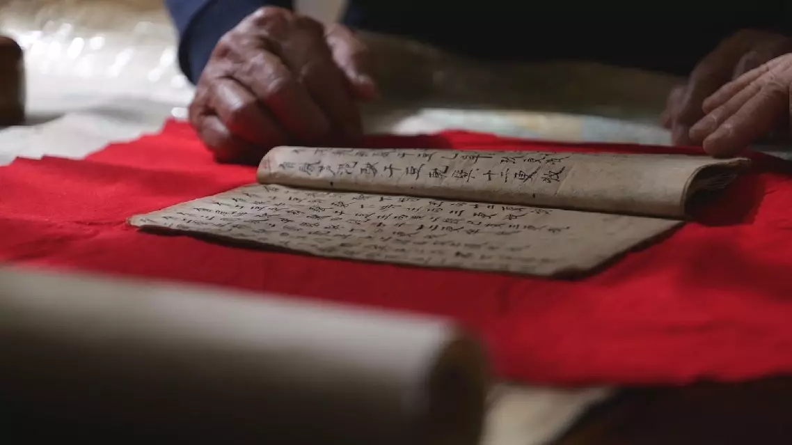
Centuries-old map shows how ancient Chinese fishermen navigated South China Sea