

In my early schooldays, travel to far and away places was just an impossible dream. Illustrations, often monochrome or sepia, on the pages of geographical magazines were an inspiration to write essays around exotic and ambitious journeys.
Tibet was one such hope as I poured over photographs of the Potala Palace, the crowded narrow market streets around Jokhang Temple at Barkhor Square, and Himalayan peaks such as Qomolangma, known as Mount Everest in the West. I mentally retained these images of the “Roof of the World”, but it would be many years before my dream was fulfilled. Despite visiting Yunnan and Qinghai in the 1990s, Tibet always felt so near, yet so far.
Click to Gallery
In my early schooldays, travel to far and away places was just an impossible dream. Illustrations, often monochrome or sepia, on the pages of geographical magazines were an inspiration to write essays around exotic and ambitious journeys.
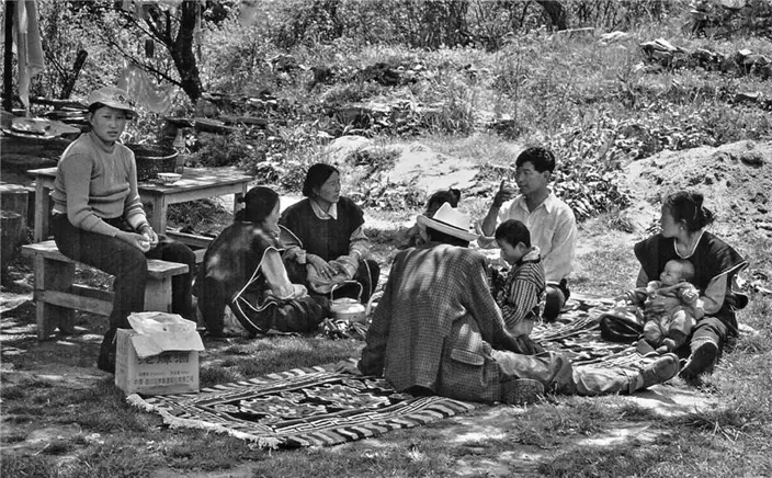
Tibetan families resting on Tashi Island 2000. (Photo by Bruce Connolly/chinadaily.com.cn)
Finally reaching reaching Lhasa in 2000, I went on to discover a location so different from my stereotyped preconceptions. Highly scenic Nyingchi, literally “throne of the sun”, covers much of southeastern Tibet. With comparisons to Switzerland, there is little physical or even human resemblance to the vast empty grasslands, high-altitude semidesert plateaus or the crowd-pulling monasteries.
On Basum Lake 2000.(Photo by Bruce Connolly/chinadaily.com.cn)
Although boasting many snow mountains reaching up to 7,782 meters, such as Namjagbarwa, Nyingchi's valleys are generally much lower than the vast Qinghai-Tibet Plateau, dropping ultimately to 900 meters. Influenced by seasonal monsoon air masses moving up from southern Asia, Nyingchi is generally humid and warmer with noticeable summer precipitation. Below the snow line, slopes are green with dense forests rich in biodiversity, while a multitude of agricultural colors, including yellow rapeseed flowers, spread across lower lying areas alongside azalea-filled meadows and colorful peach blossoms in the spring.
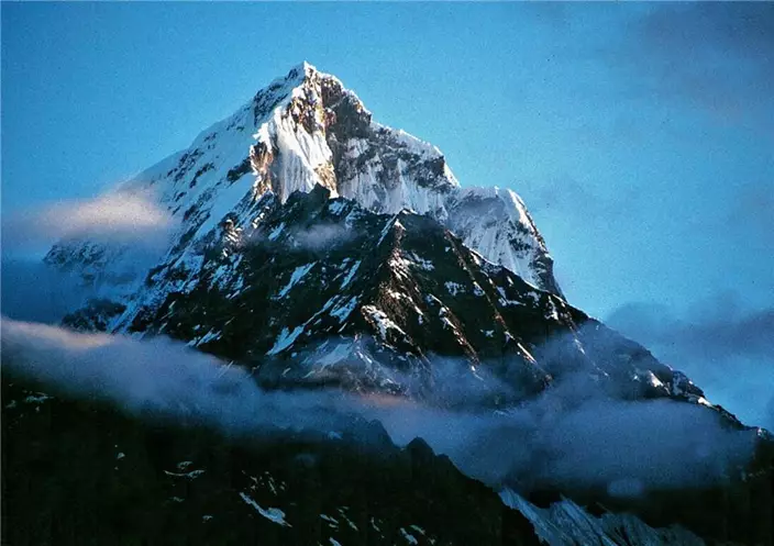
Early morning view of a snow mountain. Basum Lake 2000. (Photo by Bruce Connolly/chinadaily.com.cn)
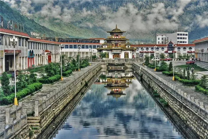
Bayi City Nyingchi 2000.(Photo by Bruce Connolly/chinadaily.com.cn)
Central to Nyingchi's geography is one of the world's mightiest river systems. The Yarlung Tsangpo rises from Angsi Glacier in Tibet's Burang county, descending in a series of giant steps toward Nyingchi. There it crashes through the dramatic gorges of the “Yarlung Tsangpo Grand Canyon” toward India and Bangladesh, where it is known by names including the Brahmaputra and Jamuna, before discharging into the Bay of Bengal via the vast Ganges Delta.
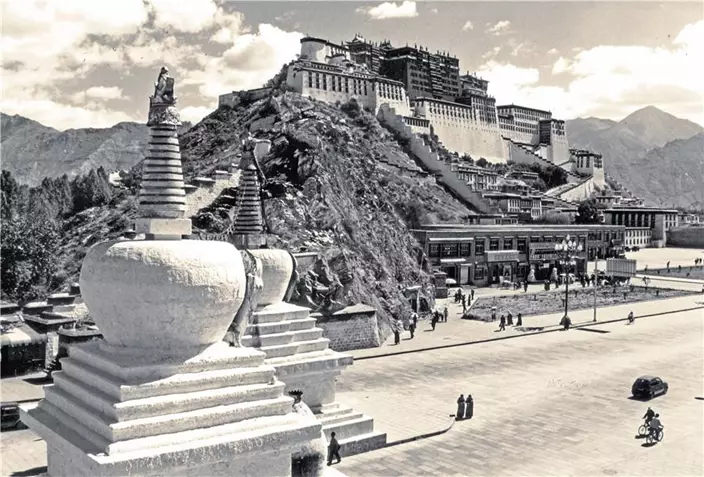
Potala Palace Lhasa 2000.(Photo by Bruce Connolly/chinadaily.com.cn)
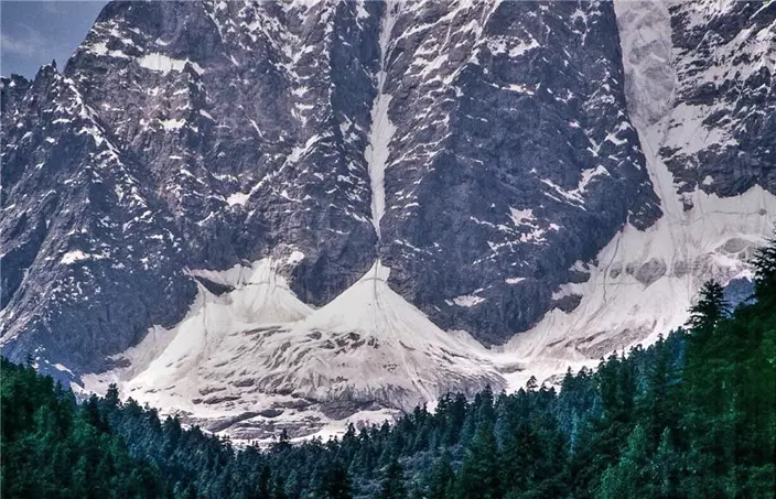
Glacial topography above Basum Lake 2000. (Photo by Bruce Connolly/chinadaily.com.cn)
Bayi sits at 2,994 meters above sea level (Lhasa is 3,400 meters high) in the Nyang River valley, a tributary of the Yarlung Tsangpo. National Highway 318 passes through, not only connecting with Sichuan and Lhasa but actually running 5,476 kilometers in total from Shanghai to Zhangmu, the town bordering Nepal.
Access to Tashi Island in 2000. (Photo by Bruce Connolly/chinadaily.com.cn)
Domestic house styles north of Bayi 2000. (Photo by Bruce Connolly/chinadaily.com.cn)
In 1997, I traveled on what was called the “Tibet Railway” terminating at Golmud in Qinghai. It was reckoned physically impossible to build a railway onto Lhasa. However through groundbreaking engineering and new technology, combined with sheer human labor, the line was eventually pushed through to Lhasa, opening July 1, 2006. The railway not only provided movement of goods to and from Tibet but also greatly boosted tourist numbers. Nyingchi tapped into this initially by modern highway connectivity. In 2014, construction also started on a line to link Bayi with Lhasa, expected to open around 2020. By 2030 this should be integrated into the Chengdu-Lhasa Railway. Compared to the 2006 achievement, its route will traverse incredibly more difficult geological terrain between Sichuan and Tibet. Inevitably this will bring in many more visitors, stimulating the local economy while creating challenges for successful and sustainable management of Nyingchi's precious environment.
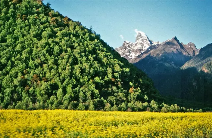
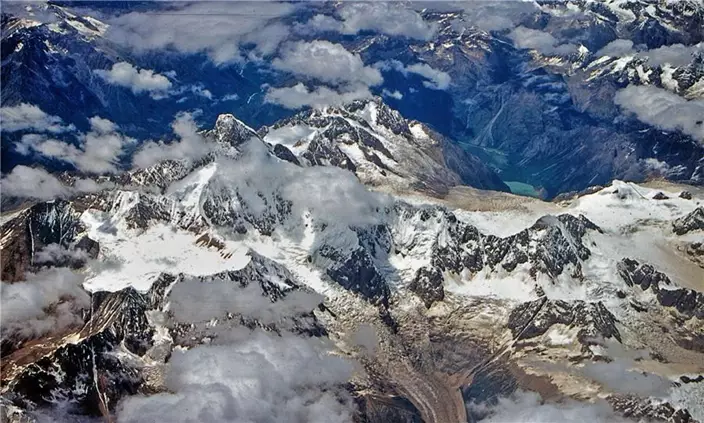
Snow mountains between Sichuan and Tibet 2000. (Photo by Bruce Connolly/chinadaily.com.cn)
Tibetan families resting on Tashi Island 2000. (Photo by Bruce Connolly/chinadaily.com.cn)
Finally reaching reaching Lhasa in 2000, I went on to discover a location so different from my stereotyped preconceptions. Highly scenic Nyingchi, literally “throne of the sun”, covers much of southeastern Tibet. With comparisons to Switzerland, there is little physical or even human resemblance to the vast empty grasslands, high-altitude semidesert plateaus or the crowd-pulling monasteries.
Nyingchi is within a long but relatively narrow range of the world’s highest mountains stretching right across Tibet’s southern edge into neighboring Yunnan and Sichuan provinces. Earth forces, plate tectonics, are responsible for this landscape. Over countless geological eras the surface of our planet has been slowly moving, almost imperceptibly -- except when there are earthquakes. The plate holding today’s Indian subcontinent has edged gradually northwards with incredible force, pushing up a former seabed to form the Himalayas. At over 5,000 meters on the slopes leading toward Qomolangma, I remember being shown locally discovered sea creature fossils! Glaciers and rivers subsequently eroded down through the uplift, creating the valleys and canyons that we hold in such awe.
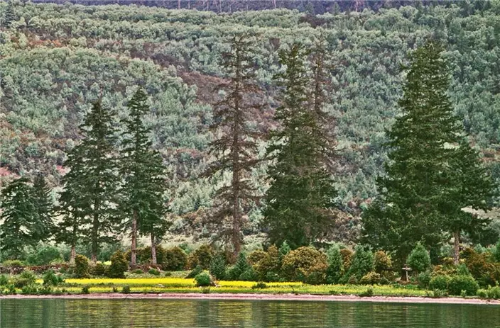
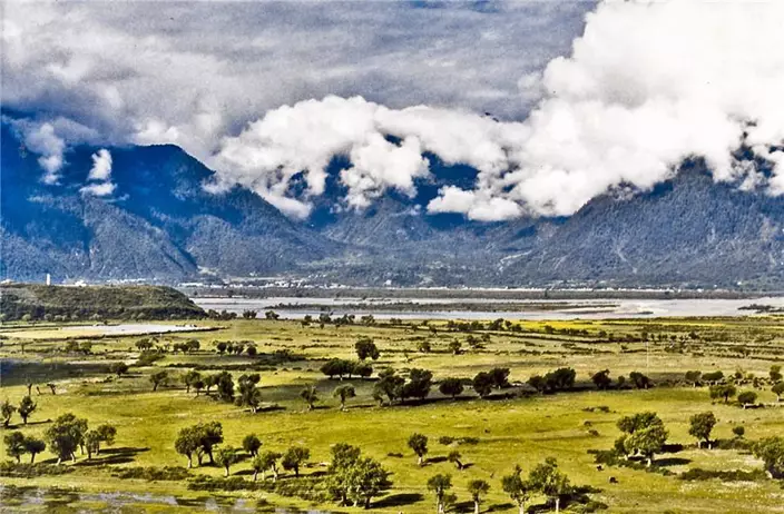
Colours of Nyingchi 2000. (Photo by Bruce Connolly/chinadaily.com.cn)
On Basum Lake 2000.(Photo by Bruce Connolly/chinadaily.com.cn)
Although boasting many snow mountains reaching up to 7,782 meters, such as Namjagbarwa, Nyingchi's valleys are generally much lower than the vast Qinghai-Tibet Plateau, dropping ultimately to 900 meters. Influenced by seasonal monsoon air masses moving up from southern Asia, Nyingchi is generally humid and warmer with noticeable summer precipitation. Below the snow line, slopes are green with dense forests rich in biodiversity, while a multitude of agricultural colors, including yellow rapeseed flowers, spread across lower lying areas alongside azalea-filled meadows and colorful peach blossoms in the spring.
Nyingchi reveals textbook glacial landscapes. Valley floors are crisscrossed with multitudes of water channels braiding through vast deposits of sand and gravel. Streams and rivers moving with tremendous speed and velocity emerging from countless high-mountain glaciers lose momentum as slopes level out, depositing much of the eroded materials they had transported earlier.
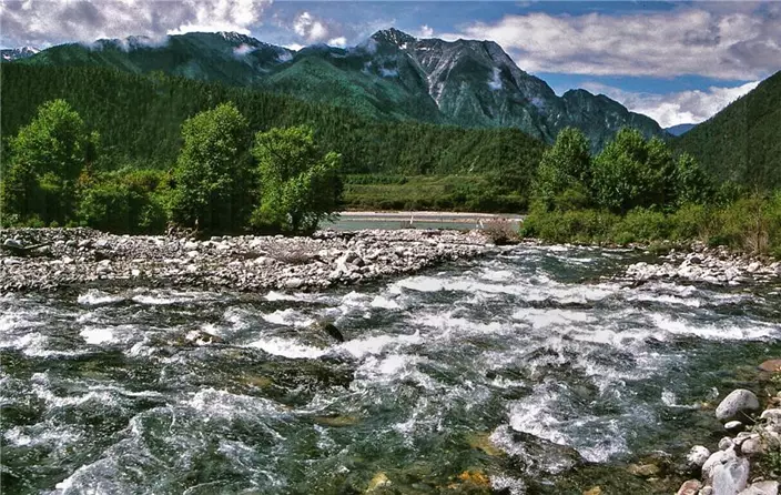
Glacial river alongside Highway 318 Nyingchi 2000. (Photo by Bruce Connolly/chinadaily.com.cn)
Early morning view of a snow mountain. Basum Lake 2000. (Photo by Bruce Connolly/chinadaily.com.cn)
Bayi City Nyingchi 2000.(Photo by Bruce Connolly/chinadaily.com.cn)
Central to Nyingchi's geography is one of the world's mightiest river systems. The Yarlung Tsangpo rises from Angsi Glacier in Tibet's Burang county, descending in a series of giant steps toward Nyingchi. There it crashes through the dramatic gorges of the “Yarlung Tsangpo Grand Canyon” toward India and Bangladesh, where it is known by names including the Brahmaputra and Jamuna, before discharging into the Bay of Bengal via the vast Ganges Delta.
My journey in 2000 was by road following several sections of the Yarlung Tsangpo – an incredibly spectacular journey for me as a geographer, but to be honest, at times terrifying as well. Tibet’s principal highways have mostly been upgraded, but in 2000 only a few sections were paved. Most were gravel, often perched on ledges cut from cliff faces high above cascading rivers or twisting in countless hairpins, with no safety barriers, up and over prayer-flag-dotted mountain passes. Thankfully Tibetan drivers appeared very skillful in handling situations that would feel quite intimidating for some lowlanders! Approaching Bayi, the administrative center of Nyingchi, the roads were good, the valleys wide, and I was much more relaxed than the earlier mountain crossings.
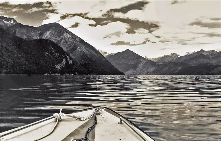
Shoreline of Basum Lake 2000. (Photo by Bruce Connolly/chinadaily.com.cn)
Potala Palace Lhasa 2000.(Photo by Bruce Connolly/chinadaily.com.cn)
Glacial topography above Basum Lake 2000. (Photo by Bruce Connolly/chinadaily.com.cn)
Bayi sits at 2,994 meters above sea level (Lhasa is 3,400 meters high) in the Nyang River valley, a tributary of the Yarlung Tsangpo. National Highway 318 passes through, not only connecting with Sichuan and Lhasa but actually running 5,476 kilometers in total from Shanghai to Zhangmu, the town bordering Nepal.
In 2000, the only feasible option in and out of Tibet was by air to Gonggar Airport alongside a wide stretch of the Yarlung Tsangpo around 90 minutes from Lhasa. Road was then the principal means of travel within the region. In recent years local airports have gradually been commissioned. Nyingchi's Mainling Airport sits alongside the Yarlung Tsangpo 40 kilometers southwest of Bayi. With a challenging geography its opening in 2006 was only possible with modern jetliners modified for high-altitude work, including advanced navigation landing technology. An incredible story, well worth reading.
Landscape near Bayi 2000.(Photo by Bruce Connolly/chinadaily.com.cn)
Access to Tashi Island in 2000. (Photo by Bruce Connolly/chinadaily.com.cn)
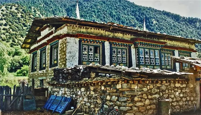
Domestic house styles north of Bayi 2000. (Photo by Bruce Connolly/chinadaily.com.cn)
In 1997, I traveled on what was called the “Tibet Railway” terminating at Golmud in Qinghai. It was reckoned physically impossible to build a railway onto Lhasa. However through groundbreaking engineering and new technology, combined with sheer human labor, the line was eventually pushed through to Lhasa, opening July 1, 2006. The railway not only provided movement of goods to and from Tibet but also greatly boosted tourist numbers. Nyingchi tapped into this initially by modern highway connectivity. In 2014, construction also started on a line to link Bayi with Lhasa, expected to open around 2020. By 2030 this should be integrated into the Chengdu-Lhasa Railway. Compared to the 2006 achievement, its route will traverse incredibly more difficult geological terrain between Sichuan and Tibet. Inevitably this will bring in many more visitors, stimulating the local economy while creating challenges for successful and sustainable management of Nyingchi's precious environment.
It was unexpected to find such a relatively modern, pleasant city as Bayi in what at first would seem a geographically isolated area. Although just an overnight stop, I would love to have spent longer for I went out in the evening and early morning to explore. It had its own vibrancy, and I also noticed the food served appeared more Sichuan in character than Tibetan. Near the city was an area of protected cypress trees. One reckoned to be around 2,500 years old was surrounded by prayer flags, having important significance to followers of Bon, the oldest indigenous religion within Tibet and still present in parts of Nyingchi.
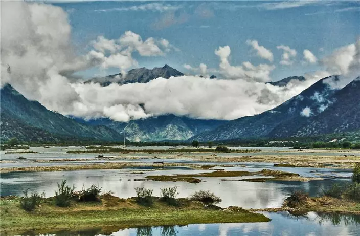
Clouds, mountains and river. Nyingchi 2000.[(Photo by Bruce Connolly/chinadaily.com.cn)
Traveling north of Bayi on Highway 318, domestic rural architecture revealed a greater use of wood and intricate design. Nyingchi is regarded as having physical similarities to Switzerland with Basum Tzo Lake representing the epitome. At Bahezhen, a narrow road that was unpaved in 2000 headed east from Highway 318 following the Bahe river valley. It wound through farmland, passing several small villages and at one point crossing the rapid plunging waters by a simple log bridge.
After Cuogaoxiang the road climbed though forests emerging at an altitude of 3,538 meters to a stunning view of a 18-kilometer-long Basum Tzo in the shape of a crescent. The emerald green waters reflecting a wealth of staggering 6,000-meter-high snow mountains holding vast swathes of dark forest below exposed sheer rock cliffs. The lake goes by several names including Cuogao (“green water”) and Draksum Tzo (“Three Rocky Mountain Lake”).
In 2001, the Basum Tzo area became a National Forest Park. The entire locale, both beautiful and tranquil, boasts textbook examples of glacial topography including hanging valleys, cirques, pyramid peaks and glaciers that supply clear, fresh water to the lake. The lake itself appears to have been the result of glacial gouging during colder times. The shoreline combines patches of farmland with lush natural vegetation. The waters, rich in fish, attract a range of bird life including sand gulls and white cranes, while the forests are home to bears, leopards, goats, musk deer and snow roosters.
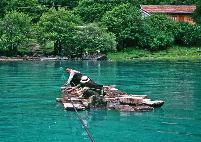
Close to the southern bank near the outflow from the lake is small, delightful Tashi Island. Access in 2000 was by a log raft that was pulled along a wire rope to the island, 100 meters from the shore. Today a wooden causeway allows easy visitor access. Only around 2,000 square meters, Tashi is home to the Nyingma Sect’s wooden two-floor Tsodzong Monastery originating over 1,500 years ago. Many Tibetans come annually to circumambulate the lake, which is a holy lake for Nyingmapa Buddhism. Visiting the island, they light butter lamps, burn joss sticks and pray in the monastery before following clockwise a shore path adorned with many prayer flags.
A highlight was a cruise from the island on the calm waters by small boat for an hour, coming close into shore or sitting midlake while looking up at spectacular rocky peaks. It was also an experience staying overnight in a log cabin set within the forest overlooking the lake. With no nearby mechanical noise, the sounds of nature were all around. It proved a golden opportunity to reflect on this captivating part of Tibet. In 2000, only a few visitors passed through but with the passage of time, with new transportation routes developing, increasingly more tourists will experience Nyingchi. This is good for the local economy, but the task is to manage that growth in such a way that the physical and human diversity, the area’s main attractions, are managed sustainably to retain its attractiveness. Much of the area around Basum Lake and indeed Nyingchi is a pristine environment that matured over many centuries or longer. Such areas can be fragile, easily damaged by human intrusion. It can be challenging to find the correct balance.
By early morning, the sunrise was bathing a snow mountain in a reddish-pink glow -- a perfect end to discovering Nyingchi. Heading northwest back along Highway 318, increasingly the landscape was drier, trees were fewer and yaks grazed on plateau grasslands. Gradually the Potala Palace came into view. Lhasa!