MUNICH & PFORZHEIM, Germany--(BUSINESS WIRE)--Jun 10, 2026--
For the major economies, the transformation towards a climate-neutral industry is one of the central tasks for the coming decades. While the European Union has pledged climate neutrality by 2050, China’s goal is to be climate-neutral by 2060. Hydrogen is a key to transforming their manufacturing and energy industry. However, the actual market development is lagging behind these ambitious objectives: According to the Global Energy Report 2025, only 11 percent of hydrogen projects announced since the start of the decade are now in operation or have been secured by investment decisions. This is why ees Europe, Europe’s largest and most international exhibition for batteries and energy storage systems, is putting a spotlight on hydrogen. The newly aligned exhibition segment Hydrogen Dialogue Forum & Expo in hall B2 will be giving in-depth information about the opportunities for hydrogen technology, technological innovation, savings potential and ground-breaking projects from June 23–25. The exhibition will be complemented by the Hydrogen Dialogue Summit taking place at ICM – Internationales Congress Center München on June 24 and 25. ees Europe is one of four exhibitions held as part of The smarter E Europe. Around 2,800 exhibitors and over 100,000 trade visitors are expected.
This press release features multimedia. View the full release here: https://www.businesswire.com/news/home/20260610934701/en/
According to the Global Energy Report 2025, around 100 million metric tons of hydrogen were produced in 2024. Around 99 percent came from fossil fuels. The ongoing energy crisis is driving home the consequences of fossil dependency. “The repeated price shocks and supply risks that are inherent to the fossil energy industry are raising awareness of the strategic value of renewables and green hydrogen,” says Markus Elsässer, founder and CEO of Solar Promotion GmbH. “A future-proof energy system depends on more than the production of clean electricity. We also have to ensure its intelligent storage and cross-sector availability. Only by flexibly coupling decentralized generation, modern battery storage and hydrogen electrolysis can we ensure a secure energy supply for industry. Green hydrogen is a key lever to make Germany’s and Europe’s energy supply resilient and technologically independent with stable electricity prices.”
The industry desperately needs this energy carrier for steel production, high-temperature processes exceeding 1,000 Celsius and the production of synthetic fuels for heavy goods, sea and air transport. So far, however, there are not enough electrolyzers to implement this. “The role of hydrogen as an energy carrier of the future is still not fully recognized. The Hydrogen Dialogue covers the entire value chain and is designed to set a clear signal in favor of ramping up production,” says Jens Mohrmann, Managing Director of Freiburg Wirtschaft Touristik und Messe GmbH & Co. KG (FWTM).
Hydrogen Dialogue Summit 2026
The Hydrogen Dialogue Summit will be shedding light on the hydrogen industry’s current trends and challenges. On June 24, the spotlight will be on Germany. On June 25, all eyes will turn to Europe and the wider world. On both days, policymakers and industry leaders will be discussing the strategic importance of hydrogen for a future resilient and climate-friendly energy supply with German and European decision makers from industry and associations. The Hydrogen Dialogue Summit is sponsored by Bavarian Minister of State for Economic Affairs, Regional Development and Energy, Hubert Aiwanger, who will be opening the event.
For more information, please visit:
www.ees-europe.com
www.TheSmarterE.de

Overview of the competitiveness of green hydrogen. ©Solar Promotion GmbH
MEXICO CITY (AP) — Hurricane Polo has grown into one of the most powerful Pacific cyclones in decades and was expected to skirt Mexico’s southwestern coast as a Category 5 storm, while Pacific system, Odalys, has strengthened from a tropical storm to a hurricane without threatening land.
The U.S. National Hurricane Center in Miami on Tuesday night called Polo an “extremely dangerous” storm and forecast the system would turn sharply to the northwest before moving west-northwest over the next several days.
Early Wednesday, Polo was about 185 miles (300 kilometers) south of Zihuatanejo and 335 miles (540 kilometers) southeast of Manzanillo moving north at 2 mph (4 kph) with maximum sustained winds of 155 mph (255 kph), the center reported.
Odalys strengthened to a Category 1 hurricane early Wednesday and was about 1,295 miles (2,085 kilometers) off the southern tip of Baja California moving east-northeast at 9 mph (15 kph) with maximum sustained winds of 75 mph (120 kph), the hurricane center said.
Mexican President Claudia Sheinbaum said experts indicated Polo was not likely to touch land. Still, hurricane-force winds extend up to 40 miles (65 kilometers) from the storm's center and tropical storm-force winds up to 105 miles (169 kilometers) from the eye, the U.S. center said.
Tropical storm conditions were expected along the Pacific coast in Guerrero, Michoacan and Colima states Wednesday into Thursday.
Polo is the third Category 5 hurricane of the Pacific season, following Genevieve and Lowell earlier this year. Category 5 is the highest level on the Saffir-Simpson scale, reflecting that a storm has maximum sustained winds exceeding 157 mph (253 kph).
The hurricane set residents along Mexico’s Pacific coast on edge once again after being walloped by a number of powerful cyclones in recent years. Beaches emptied and dark clouds swirled above choppy seas, while Mexican authorities temporarily suspended classes Tuesday in a number of areas. Mexico’s navy shut down ports in the states of Guerrero and Michoacán and warned civilians and fishermen to take care.
Concepción López Villegas was busily preparing her seaside restaurant for what may come. Strong waves were already lapping at the coastline of her city Lázaro Cárdenas in Michoacán. As men and children watched the stirring waters behind her, López Villegas said she feared powerful waves would destroy the small business she has worked decades to build.
“We're worried and trying to protect our businesses,” López Villegas said. “And of course, we're sad because it's our heritage, our legacy that from one moment to another could be destroyed.”
U.S. National Hurricane Center data shows Polo's winds reached speeds comparable to only a few hurricanes in the region in recent decades, primarily Hurricane Patricia, which had winds that reached 215 mph (346 kph) in 2015.
“This is one of the strongest storms ever in the (Pacific) Basin,” said Kristen L. Corbosiero, professor at the University at Albany’s Department of Atmospheric & Environmental Sciences.
Heavy rain could produce flash flooding and mudslides. About 3 to 6 inches (8 to 15 centimeters) of rain was forecast for Guerrero and Michoacán states, with smaller amounts possible for coastal portions of Oaxaca, Colima and Jalisco states.
The U.S. Embassy in Mexico issued a weather alert, instructing citizens to avoid water and beaches and to heed warnings from Mexican authorities.
“Even if the storm does not make direct landfall, heavy rain may produce life-threatening flooding and mudslides. Hazardous ocean conditions — intensified by storms — may result in deadly rip currents and rogue waves,” the embassy wrote in a statement.
The rapid intensification of the storm has stunned scientists and authorities alike, with the NHC writing in a report that it was “truly remarkable” how quickly Polo gained strength in 24 hours.
Philip Klotzbach, research scientist in the Department of Atmospheric Science at Colorado State University, attributed the intensification to the weather phenomenon known as El Niño, which has fueled crippling droughts in Mexico and Central America and floods in other parts of the region.
In the Pacific, it has resulted in warmer waters and wind patterns that act as fodder for hurricanes, he said.
“There are all the ingredients that hurricanes need to get really strong really fast,” Klotzbach said.
No Atlantic hurricanes have formed yet this year, and this year has set a record for the longest start to a season without a hurricane. The effects of this year’s El Niño crush storms before they get going.
Brooks reported from Atlanta.
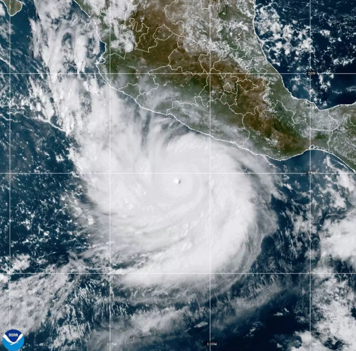
This photo provided by NOAA shows Hurricane Polo strengthening in the Pacific Ocean off the coast of Mexico on Tuesday, Sept. 22, 2026. (NOAA via AP)
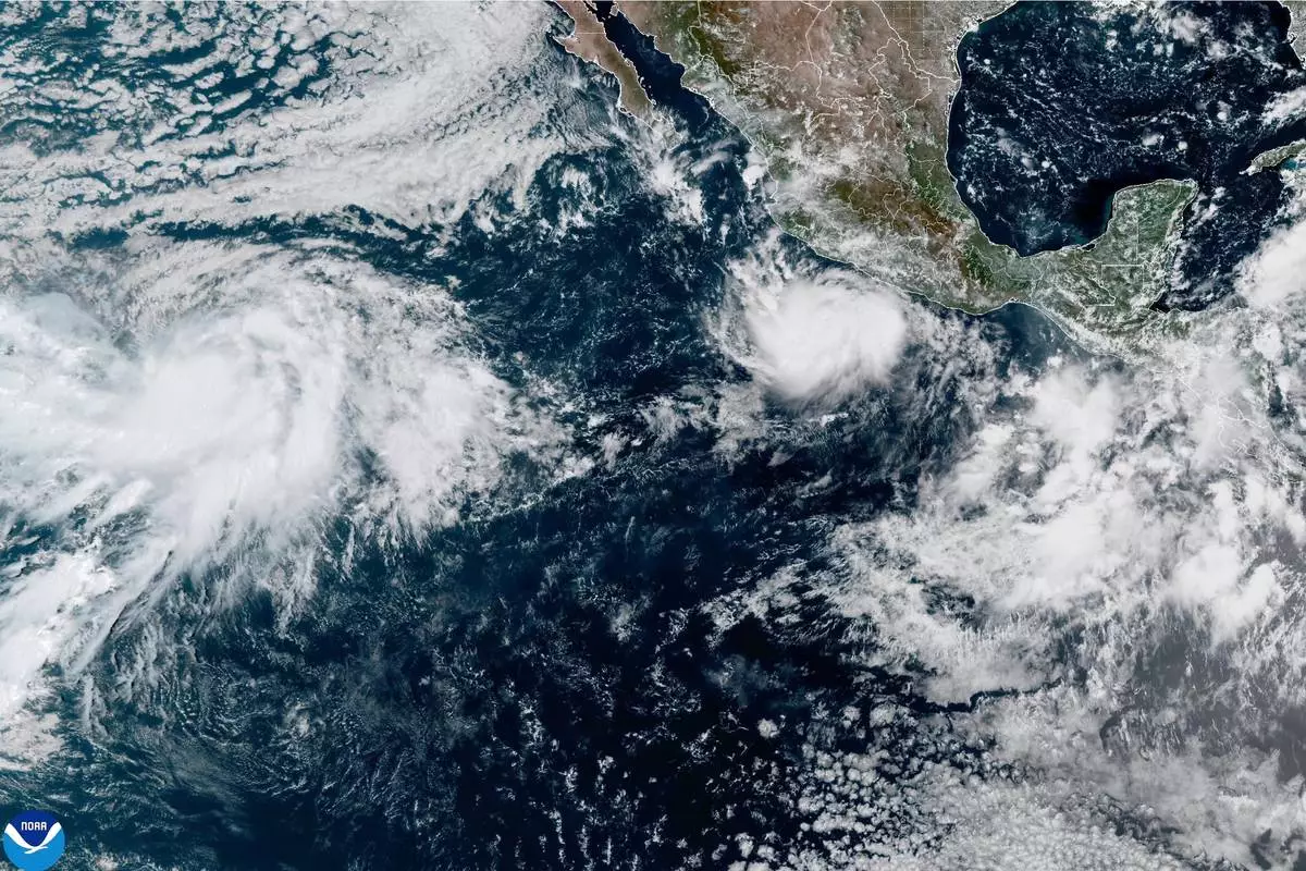
This photo provided by NOAA shows Hurricane Polo intensifying in the Pacific Ocean off the coast of Mexico on Monday, Sept. 21, 2026. (NOAA via AP)