VANCOUVER, British Columbia--(BUSINESS WIRE)--Jul 14, 2026--
Spanish Mountain Gold Ltd. (the “ Company ” or “ Spanish Mountain Gold” ) (TSX-V: SPA) (FSE: S3Y) (OTCQB: SPAUF) is pleased to provide assay results from seven diamond drill holes on the Spanish Mountain Gold project (the “Project”), located in the Cariboo Gold Corridor, British Columbia, Canada.
Click to Gallery
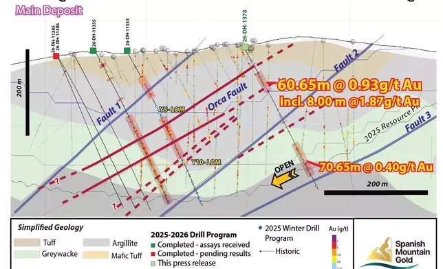
Figure 4: Drill Section through the southern Main Deposit between Fault 2 and Fault 3 (looking northeast); Section Line C-C’, Figure 1.
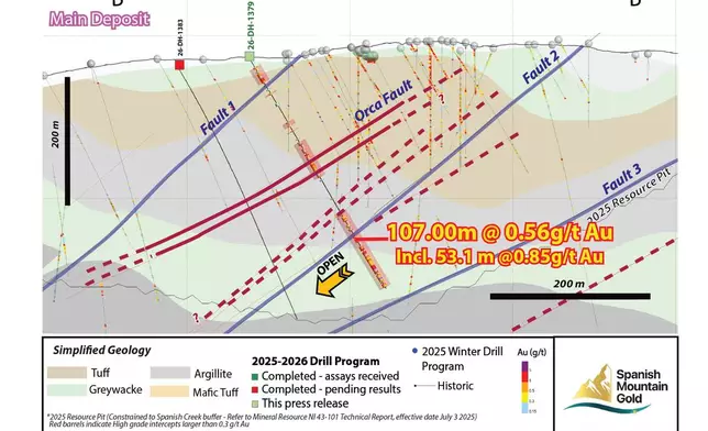
Figure 3: Drill Section through the Orca Fault Corridor (looking northeast); Section Line B-B’, Figure 1.
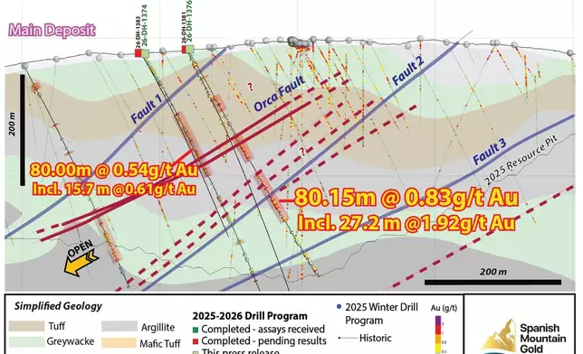
Figure 2: Drill Section (30 m thickness) through the Orca Fault corridor (looking northeast); section line A-A’ Figure 1.
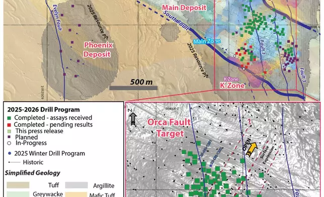
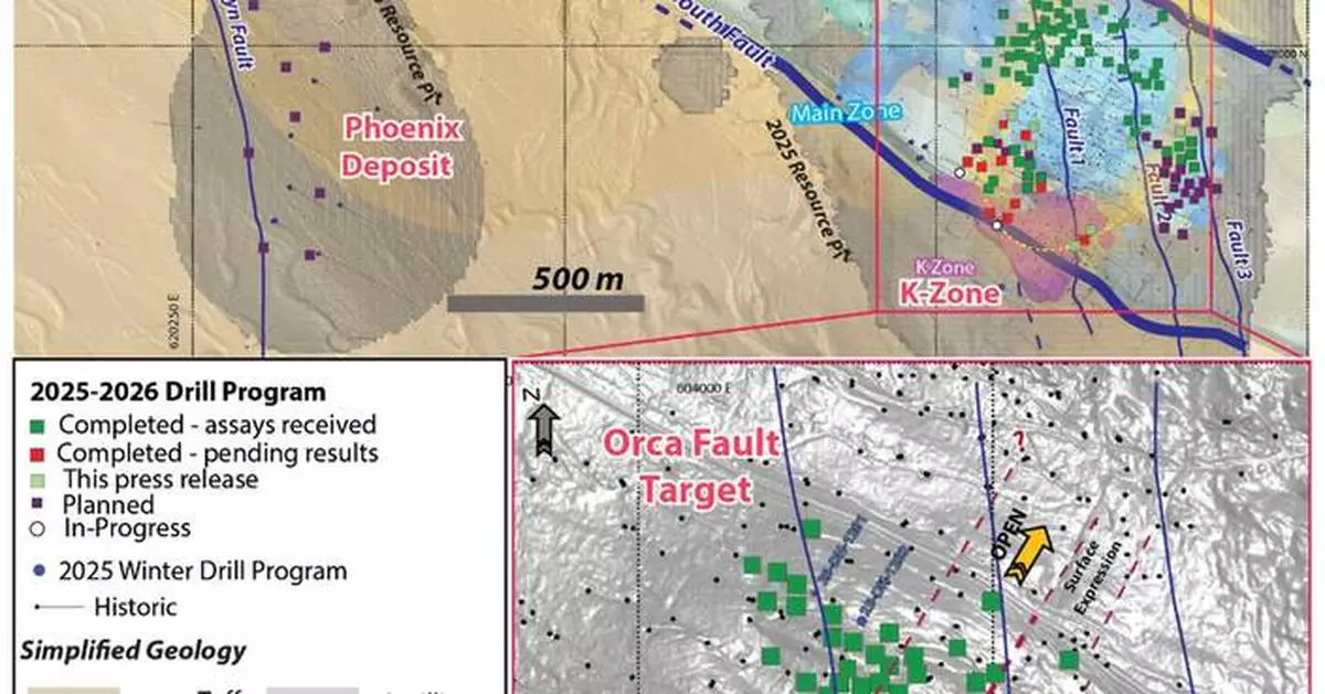
Figure 1: Drill Collar Location Map - 2025-2026 Drill Program. The figure illustrates the collar locations for all 7 drill holes reported in this news release, plus holes with assays pending. Section lines correspond to drill cross-sections presented in Figures 2, 3, and 4. Collar coordinates are summarized in Table 5.
This press release features multimedia. View the full release here: https://www.businesswire.com/news/home/20260714888685/en/
The assay results from these drill holes are part of the 2026 Feasibility Drill Program, which was initiated in March 2026 with the objective of increasing resource confidence (infill drilling) and expanding on the current mineral resource. Approximately 17,143 metres (“m”) of a planned 60,000 m drilling program has been completed to date. This news release presents results for holes 26-DH-1374 to 26-DH-1380. Assay results are pending for 19 additional drill holes.
Highlights:
Key Findings - 7 Drill Holes
Abbreviations: metres = m, grams per tonne = g/t, gold = Au, mineral resource estimate = MRE, Spanish Mountain Gold = SMG. LOM = Life-of-mine
Drill Results
Section A-A’ (Figure 2) - Drill Holes 26-DH-1374 and 26-DH-1376
26-DH-1374 and 26-DH-1376 were collared to test the Orca Fault Corridor on the western side of the Main Deposit. 26-DH-1374, collared approximately 100 m northeast of 26-DH-1370, demonstrates continuity along the interpreted Orca corridor, intersecting a broad interval of 364.0 m of 0.24 g/t gold from 9.0 m, including 80.0 m of 0.54 g/t gold from 123.0 m with internal higher-grade zones of 15.7 m of 0.61 g/t gold from 130.4 m and 34.0 m of 0.65 g/t gold from 162.0 m. Results are summarized in Table 1.
26-DH-1376 is the standout hole of Section A-A’, returning 303.18 m of 0.50 g/t gold from 76.02 m, including a high-grade upper zone of 209.13 m of 0.61 g/t gold from 76.02 m with 24.83 m of 1.22 g/t gold from 76.02 m and 9.7 m of 2.72 g/t gold from 89.0 m near surface, a middle zone of 41.0 m of 0.64 g/t gold from 142.0 m with 18.14 m of 1.07 g/t gold from 161.0 m, and a deeper zone of 80.15 m of 0.83 g/t gold from 205.0 m including a higher-grade vein cluster of 27.2 m of 1.92 g/t gold from 242.8 m. Mineralization remains open at depth and it is interpreted to be consistent with the top of the third argillite target defined in 2024 (see news release from December 18, 2024). Results are summarized in Table 1.
Table 1: Assay Results for 26-DH-1374 and 26-DH-1376
Section B-B’ (Figure 3) - Drill Hole 26-DH-1379
26-DH-1379, collared 50 m northeast of 26-DH-1376, intersected three separate mineralization zones associated with the Orca Fault Corridor, confirming structural continuity across an interval of 314.0 m of 0.35 g/t gold from 14.0 m.
Zone 1 (near surface): 22.0 m of 0.72 g/t gold from 14.0 m, including 13.0 m of 1.08 g/t gold from 23.0 m.
Zone 2 (intermediate): 50.5 m of 0.50 g/t gold from 120.5 m, including 14.0 m of 0.78 g/t gold from 151.5 m.
Zone 3 (deep): 107.0 m of 0.56 g/t gold from 221.0 m, including 53.1 m of 0.85 g/t gold from 270.9 m and a tighter higher-grade interval of 40.35 m of 0.99 g/t gold from 270.9 m. Mineralization remains open at depth and along strike.
Table 2: Assay Results for 26-DH-1379
Section C-C’ (Figure 4) - Drill Hole 26-DH-1378
26-DH-1378, collared 210 m southeast of 26-DH-1359, was designed to test gold mineralization in the southern part of the Main Deposit between Fault 2 and Fault 3, within the Years 5–10 life-of-mine shells defined in the 2025 PEA (see news release from July 3, 2025) and towards the 2025 MRE resource pit bottom. The hole intersected 243.1 m of 0.38 g/t gold from 39.55 m, including a strong near-surface zone of 60.65 m of 0.93 g/t gold from 39.55 m with a high-grade interval of 2.2 m of 3.97 g/t gold from 98.0 m and a narrow Orca-style vein of 0.7 m of 56.61 g/t gold from 57.8 m. A deeper zone of 70.65 m of 0.40 g/t gold from 212.0 m remains open along strike and at depth.
Table 3: Assay Results for 26-DH-1378
Eastern Block - Drill Holes 26-DH-1375, 26-DH-1377, and 26-DH-1380
26-DH-1375 and 26-DH-1377 were collared in the eastern block to help delineate the structural controls for this part of the project, interpreted as part of the Orca Fault Corridor extending to the east. Both holes confirm near-surface mineralization, with 26-DH-1377 intercepting gold from 15.0 m and 26-DH-1375 from 49.00 m, contributing to the definition of the eastern corridor limits.
26-DH-1375 intersected 95.0 m of 0.40 g/t gold from 49.0 m, including 53.8 m of 0.58 g/t gold from 90.2 m, and a higher-grade subset of 24.0 m of 0.94 g/t gold from 95.0 m.
26-DH-1377 returned 135.0 m of 0.32 g/t gold from 15.0 m, including 81.25 m of 0.40 g/t gold from 38.55 m and a higher-grade zone of 10.15 m of 1.10 g/t gold from 109.65 m.
26-DH-1380 returned broad lower-grade intervals of 117.0 m of 0.24 g/t gold from 12.0 m and 39.0 m of 0.35 g/t gold from 209.0 m, with a near-surface higher-grade subset of 10.1 m of 1.46 g/t gold from 12.0 m. Results for all three holes are summarized in Table 4.
Table 4: Assay Results for 26-DH-1375, 26-DH-1377, and 26-DH-1380
Drill Core Processing, Data Verification and Quality Assurance – Quality Control Program (QAQC)
Once received from the drill and processed, all drill core samples were sawn in half, labeled, and bagged. The remaining half of the drill core was securely stored on-site. Numbered security tags were applied to sample shipments to ensure chain of custody compliance. The Company inserts quality control (QC) samples at regular intervals, including blanks and reference materials, for all sample shipments to monitor laboratory performance. Standards, blanks, preparation and field duplicates account for a minimum of 20% of the samples in addition to the laboratory's internal quality assurance programs. The QAQC program was overseen by the Company's Qualified Person, Julian Manco, P.Geo., Director of Exploration (as described below).
The data verification process involved a multi-step approach to ensure accuracy and integrity. This included a detailed quality control (QC) analysis of the data, which was performed using both internal and external platforms, such as the MxDeposit™ software. These QC checks involved the analysis of certified reference materials (CRMs), blanks, and duplicates to confirm the reliability of the assay results. In addition, a field inspection of the specific drill intervals mentioned in this release has been conducted to directly observe the geological features and verify the nature of the results presented.
Drill core samples were submitted to MSALABS's analytical facility in Prince George, British Columbia, for sample preparation and PhotonAssay™ analysis. The MSALABS facilities are accredited to the International Standards ISO/IEC 17025 and ISO 9001 standard for gold and multi-element assays, with all analytical methods incorporating quality control materials at defined frequencies and established data acceptance criteria. MSALABS Inc. is independent of the Company.
PhotonAssay™
The PhotonAssay™ method utilizes gamma ray analysis for gold detection using the Chrysos PhotonAssay™ instrument (PA1408X). This non-destructive, fully automated technique offers high accuracy for analyzing ores and pulps. Sample preparation begins with drying and crushing up to 1 kg of material to achieve at least 70% passing through a 2-millimetre (mm) sieve. The sample is then riffle split to obtain a suitable aliquot for 2 testing cycles (MSALABS Method CPA-Au1). The PhotonAssay™ instrument bombards 400- to 600-gram samples contained in sealed containers with gamma rays. Each sample is accompanied by a reference disc traceable to a Certified Reference Material (CRM). The method offers a gold detection range from 0.015 ppm (lower limit) to 10,000 ppm (upper limit).
Spanish Mountain Gold implemented two QAQC methodologies to validate the accuracy of PhotonAssay™ results, both demonstrating good comparability: 1) comparative analysis of diverse mineralization styles using Total Au screen metallic methods with both FAS-415 (gravimetric finish) and FAS-211 (AAS finish), and 2) comprehensive testing of both sample aliquots and rejects using FAS-211 (AAS finish).
Multi-Elemental Analysis
For the 2026 drilling campaign, Spanish Mountain Gold used the IMS-230 method to provide multi-element determination using a four-acid digestion followed by ICP-OES and ICP-MS analysis.
Qualified Person
Julian Manco, M.Sc., P.Geo., Director of Exploration with Spanish Mountain Gold, is the Qualified Person as defined under National Instrument 43-101 who has reviewed the technical information in this news release and has approved the content for dissemination.
About Spanish Mountain Gold Ltd.
Spanish Mountain Gold Ltd. is focused on advancing its 100%-owned Spanish Mountain Gold project towards construction of the next gold mine in the Cariboo Gold Corridor, British Columbia. On May 1, 2026, the Company received the first instalment of US$22.5 million in connection with the sale of a 1.5% NSR to Wheaton Precious Metals for US$55 million (see news release from May 1, 2026). In Q2 2026, the Company initiated a feasibility study on the Project, which is fully funded and will position the Company to make a construction decision in 2028.
The Company is seeking new ways to achieve optimal financial outcomes that are safer, minimize environmental impact and create meaningful sustainability for communities, which the Company terms “The Relentless Pursuit of Better Gold”. For more information on Spanish Mountain Gold, please visit the Company's website: www.spanishmountaingold.com or the Company’s profile on www.sedarplus.ca.
On Behalf of the Board,
“Peter Mah”
President, Chief Executive Officer and Director
Spanish Mountain Gold Ltd.
Neither the TSX Venture Exchange nor its Regulation Services Provider (as that term is defined in the policies of the TSX Venture Exchange) accepts responsibility for the adequacy or accuracy of this release.
FORWARD-LOOKING INFORMATION:
Certain of the statements and information in this press release constitute “forward-looking information”. Any statements or information that express or involve discussions with respect to predictions, expectations, beliefs, plans, projections, objectives, assumptions or future events or performance (often, but not always, using words or phrases such as “expects”, “anticipates”, “believes”, “plans”, “estimates”, “intends”, “targets”, “goals”, “forecasts”, “objectives”, “potential” or variations thereof or stating that certain actions, events or results “may”, “could”, “would”, “might” or “will” be taken, occur or be achieved, or the negative of any of these terms and similar expressions) are not statements of historical fact and may be considered forward-looking information. The Company's forward-looking information is based on the assumptions, beliefs, expectations and opinions of management as of the date of this press release and includes but is not limited to information with respect to exploration drilling extending near surface gold mineralization hosted within the Orca Fault Corridor, drilling results relating to the potential to enhance the proposed life-of-mine plan in the first 10-years of production, the receipt of the two remaining instalments from the sale of the 1.5% NSR to Wheaton Precious Metals for US$55 million, the results of the feasibility study, and the timeline to make a construction decision. Other than as required by applicable securities laws, the Company does not assume any obligation to update forward-looking information if circumstances or management's assumptions, beliefs, expectations or opinions should change, or changes in any other events affecting such statements or information. For the reasons set forth above, investors should not place undue reliance on forward-looking information.
Table 5: Drill Collar Information for Drill Holes
Collar coordinates and hole depths to be confirmed upon final survey data entry. Abbreviations: metres = m, grams per tonne = g/t, gold = Au. Collar coordinates Datum: UTM NAD83 Zone 10N
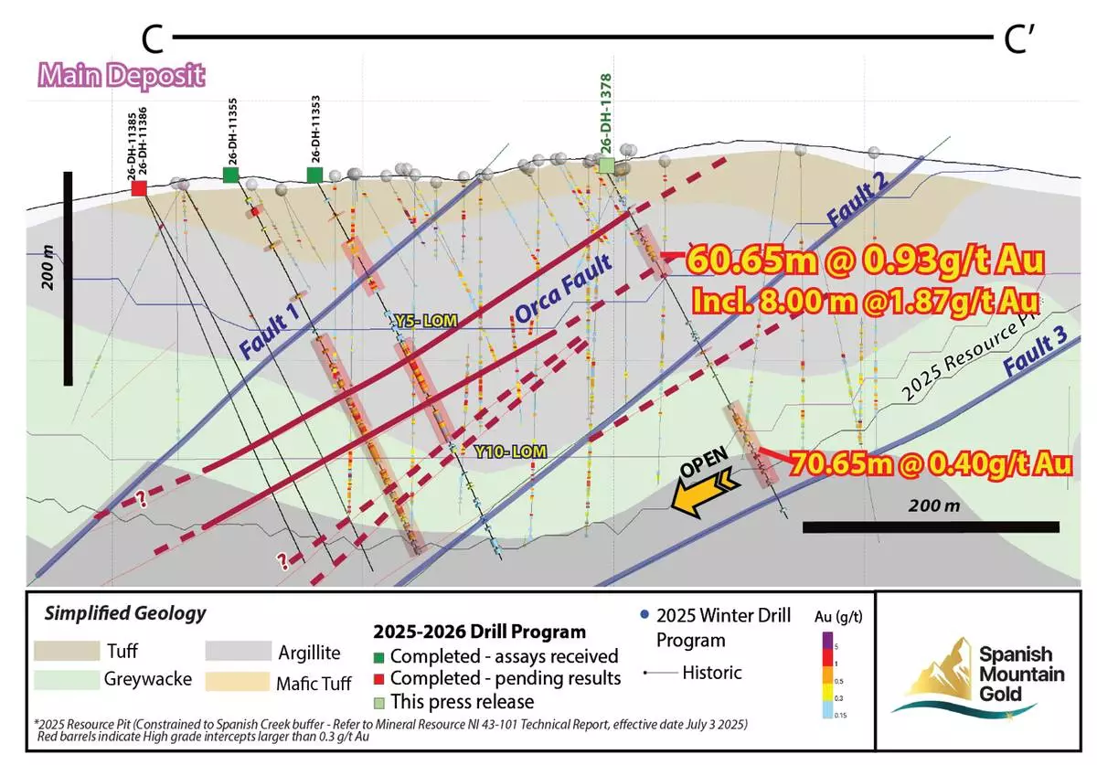
Figure 4: Drill Section through the southern Main Deposit between Fault 2 and Fault 3 (looking northeast); Section Line C-C’, Figure 1.
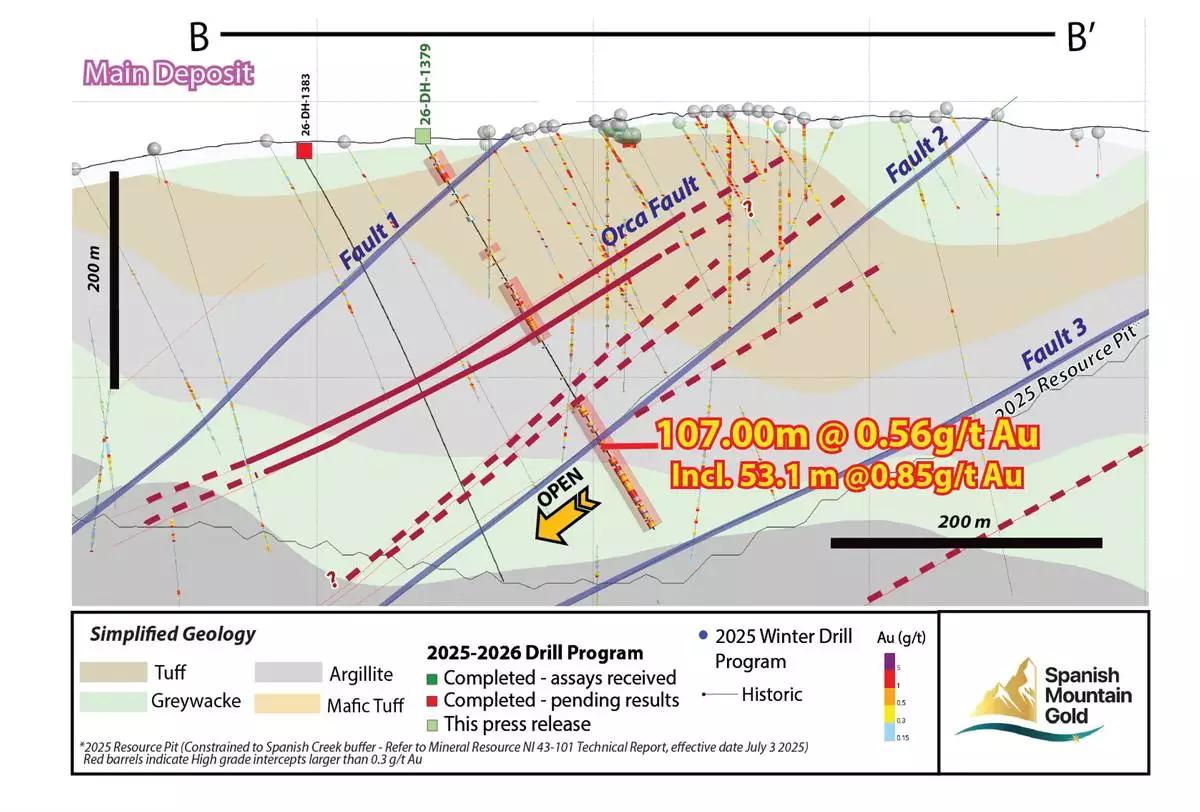
Figure 3: Drill Section through the Orca Fault Corridor (looking northeast); Section Line B-B’, Figure 1.
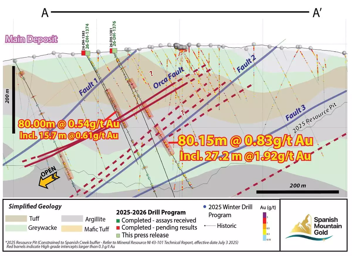
Figure 2: Drill Section (30 m thickness) through the Orca Fault corridor (looking northeast); section line A-A’ Figure 1.
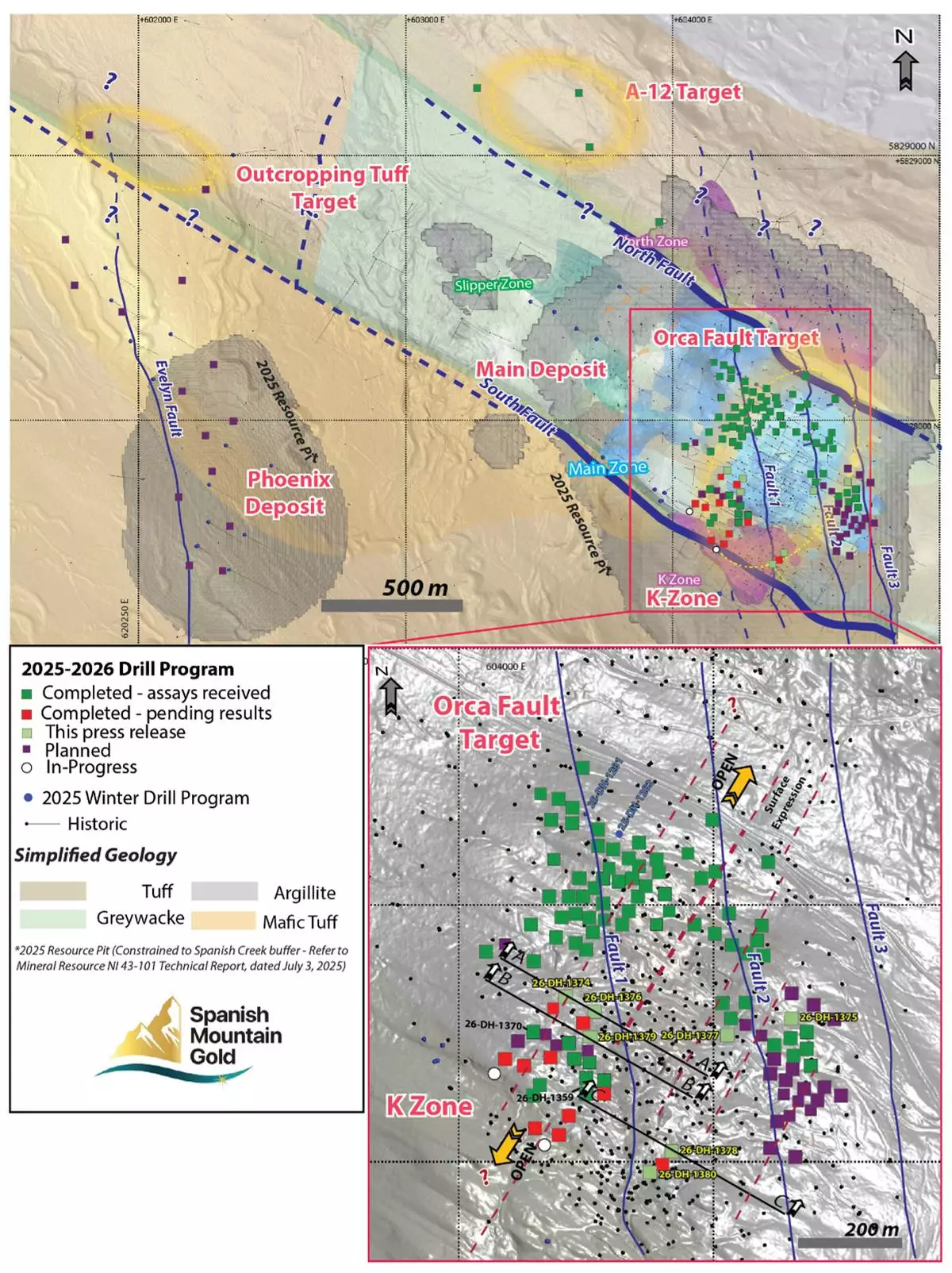
Figure 1: Drill Collar Location Map - 2025-2026 Drill Program. The figure illustrates the collar locations for all 7 drill holes reported in this news release, plus holes with assays pending. Section lines correspond to drill cross-sections presented in Figures 2, 3, and 4. Collar coordinates are summarized in Table 5.