Draft Shau Kei Wan Outline Zoning Plan approved
The Chief Executive in Council has approved the draft Shau Kei Wan Outline Zoning Plan (OZP).
"The approved OZP provides a statutory land use planning framework to guide the development and redevelopment within the Shau Kei Wan area," a spokesman for the Town Planning Board said today (December 5).
The planning scheme area, covering an area of about 201 hectares in the north-eastern part of Hong Kong Island, is bounded by Shau Kei Wan Typhoon Shelter to the north and Tai Tam Country Park to the south. To the east is Heng Fa Chuen, and to the west are the residential developments of Lei King Wan, Taikoo Shing and Kornhill.
The approved OZP has incorporated amendments shown on the draft Shau Kei Wan OZP No. S/H9/21, which mainly involve (i) rezoning a site occupied by the Former Shau Kei Wan Market (SKWM) Building and the SKWM Building Sitting-out Area from "Government, Institution or Community" ("G/IC") to "Residential (Group A)7" with stipulation of building height restriction for private residential development; and (ii) rezoning a site occupied by the Kam Wah Street Rest Garden from "G/IC" to "Open Space" to reflect the as-built condition.
The Notes and Explanatory Statement of the OZP have been amended to reflect the above amendments. Opportunity is also taken to update the general information of various land use zonings and the planning circumstances, where appropriate.
The approved Shau Kei Wan OZP No. S/H9/22 is available for public inspection during office hours at (i) the Secretariat of the Town Planning Board, (ii) the Planning Enquiry Counters, (iii) the Hong Kong District Planning Office, and (iv) the Eastern Home Affairs Enquiry Centre.
Copies of the approved OZP are available for sale at the Map Publications Centre in North Point. The electronic version of the OZP can be viewed at the Town Planning Board's website (www.tpb.gov.hk).
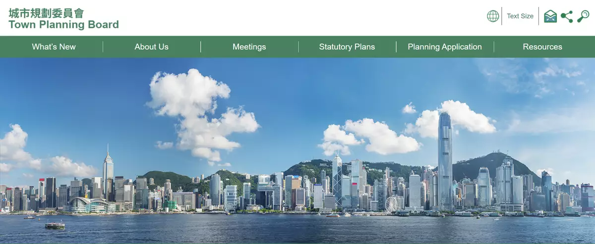
Photo source: the Town Planning Board's website
Hong Kong Customs detects two dangerous drugs cases and seizes suspected drugs worth about $7.95 million
Hong Kong Customs detected two dangerous drugs cases in Tseung Kwan O and Hong Kong International Airport respectively yesterday (May 21) and today (May 22), and seized a total of about 21.8 kilograms of assorted drugs with a total estimated market value of about $7.95 million. Two men and one woman, aged between 38 and 49, were arrested.
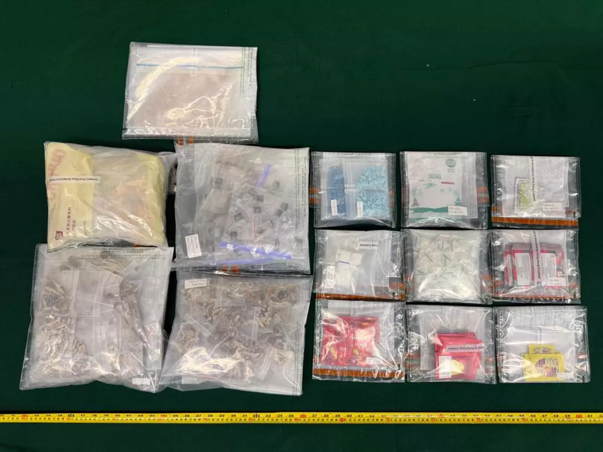
In the first case, Customs officers intercepted a 48-year-old man and a 49-year-old woman in Tseung Kwan O during an anti-narcotics operation yesterday afternoon. About 3.8kg of suspected drugs, including ketamine, methamphetamine, etomidate capsules, psilocybin mushrooms, MDMA and a batch of suspected drug packaging paraphernalia were found in their residence in the same district. They were then arrested.
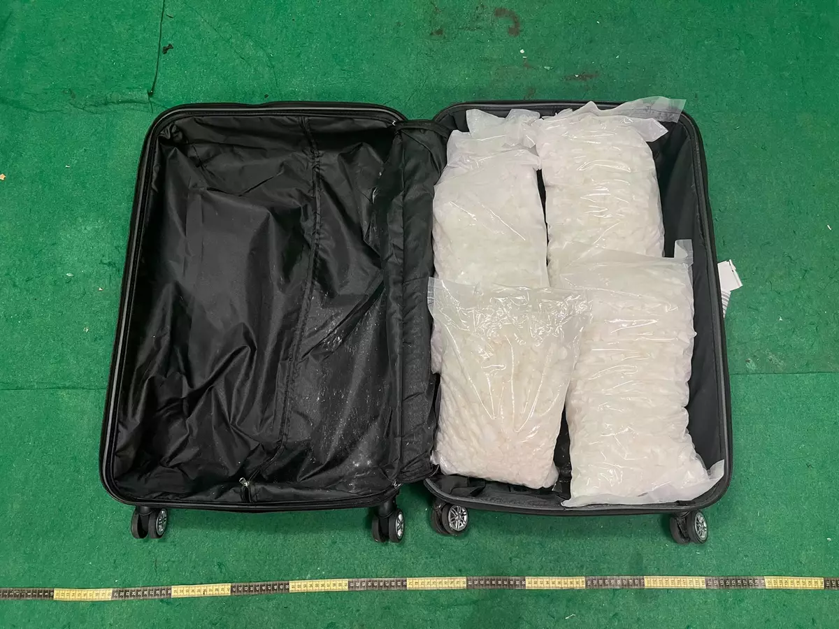
In the second case, a 38-year-old male passenger arrived in Hong Kong from Amsterdam, the Netherlands, today. During customs clearance, Customs officers found about 18kg of suspected ketamine inside his check-in suitcase and 33 sticks of duty-not-paid cigarette inside his carry-on baggage. The man was subsequently arrested.
The arrested man and woman in the first case have been jointly charged with one count of trafficking in a dangerous drug and one count of possession of apparatus fit and intended for the inhalation of a dangerous drug. The case will be brought up at the Kwun Tong Magistrates' Courts tomorrow (May 23), while an investigation is ongoing for the second case.
Customs will continue to step up enforcement against drug trafficking activities through intelligence analysis. The department also reminds members of the public to stay alert and not participate in drug trafficking activities for monetary return. They must not accept hiring or delegation from another party to carry controlled items into and out of Hong Kong. They are also reminded not to carry unknown items for other people.
Customs will continue to apply a risk assessment approach and focus on selecting passengers from high-risk regions for clearance to combat transnational drug trafficking activities.
Under the Dangerous Drugs Ordinance, trafficking in a dangerous drug is a serious offence. The maximum penalty upon conviction is a fine of $5 million and life imprisonment.
Under the Dutiable Commodities Ordinance, cigarettes are dutiable goods to which the DCO applies. Any person who imports, deals with, possesses, sells or buys illicit cigarettes commits an offence. The maximum penalty upon conviction is a fine of $2 million and imprisonment for seven years.
Members of the public may report any suspected drug trafficking activities to Customs' 24-hour hotline 182 8080 or its dedicated crime-reporting email account (crimereport@customs.gov.hk) or online form (eform.cefs.gov.hk/form/ced002).
Hong Kong Customs detects two dangerous drugs cases and seizes suspected drugs worth about $7.95 million Source: HKSAR Government Press Releases
Hong Kong Customs detects two dangerous drugs cases and seizes suspected drugs worth about $7.95 million Source: HKSAR Government Press Releases