BAKU, Azerbaijan (AP) — Isack Hadjar is staying with Red Bull as Max Verstappen's teammate for 2027 after the team extended his contract.
The confirmation Wednesday comes as Hadjar prepares to return to action at this week's Azerbaijan Grand Prix after missing three Formula 1 rounds with a wrist injury.
“The period since his injury has been a difficult one for Isack, but this extension is a testament to how much we believe in him and we can’t wait to see him back out on track,” Red Bull team principal Laurent Mekies said.
The French driver is eighth in the standings despite his absence. He's been consistent, placing in the top six in each of his last seven races, but has rarely been able to challenge four-time champion Verstappen's pace.
Mekies said Hadjar had been “superb on and off track” since moving up from Red Bull's sister team Racing Bulls after a strong rookie season in 2025, “which made extending his contract an easy decision”.
That means Verstappen will have the same teammate for a second season, the first time that's happened since Sergio Perez was dropped at the end of 2024. Red Bull dropped Liam Lawson after two races in 2025 and Yuki Tsunoda replaced him but was dropped at the end of the year.
“From the moment I signed, I set out to dedicate myself to the team, and with the support of Laurent and everyone in (Red Bull headquarters at) Milton Keynes, I’ve been able to justify the faith they’ve had in me,” Hadjar said.
See AP’s full auto racing coverage here

FILE - Red Bull driver Isack Hadjar of France walks in the drivers area ahead of the Formula One Grand Prix at the Spa-Francorchamps racetrack in Spa, Belgium, on July 16, 2026. (AP Photo/Omar Havana, File)
MEXICO CITY (AP) — Hurricane Polo has grown into one of the most powerful Pacific cyclones in decades, and it was expected to skirt Mexico’s southwestern coast as a Category 5 storm.
Polo was an “extremely dangerous” storm with maximum sustained winds of 165 mph (265 kph), the U.S. National Hurricane Center in Miami said Tuesday night.
Polo was nearly stationary early Wednesday about 200 miles (325 kilometers) south of Zihuatanejo in Guerrero state. It was forecast to turn sharply to the northwest during the day and then move in west-northwest over the next several days.
Mexican President Claudia Sheinbaum said experts indicated that the hurricane was not likely to touch land. Still, hurricane-force winds extend up to 40 miles (65 kilometers) from the storm's center and tropical storm-force winds up to 105 miles (169 kilometers) from the eye, the U.S. center said.
Tropical storm conditions were expected along the Pacific coast in Guerrero, Michoacan and Colima states Wednesday into Thursday.
The hurricane set residents along Mexico’s Pacific coast on edge once again after being walloped by a number of powerful cyclones in recent years. Beaches emptied and dark clouds swirled above choppy seas, while Mexican authorities temporarily suspended classes Tuesday in a number of areas. Mexico’s navy shut down ports in the states of Guerrero and Michoacán and warned civilians and fishermen to take care.
Concepción López Villegas was busily preparing her seaside restaurant for what may come. Strong waves were already lapping at the coastline of her city Lázaro Cárdenas in Michoacán. As men and children watched the stirring waters behind her, López Villegas said she feared powerful waves would destroy the small business she has worked decades to build.
“We're worried and trying to protect our businesses,” López Villegas said. “And of course, we're sad because it's our heritage, our legacy that from one moment to another could be destroyed.”
U.S. National Hurricane Center data shows Polo's winds reached speeds comparable to only a few hurricanes in the region in recent decades, primarily Hurricane Patricia, which had winds that reached 215 mph (346 kph) in 2015.
“This is one of the strongest storms ever in the (Pacific) Basin,” said Kristen L. Corbosiero, professor at the University at Albany’s Department of Atmospheric & Environmental Sciences.
Heavy rain could produce flash flooding and mudslides. About 3 to 6 inches (8 to 15 centimeters) of rain was forecast for Guerrero and Michoacán states, with smaller amounts possible for coastal portions of Oaxaca, Colima and Jalisco states.
The U.S. Embassy in Mexico issued a weather alert, instructing citizens to avoid water and beaches and to heed warnings from Mexican authorities.
“Even if the storm does not make direct landfall, heavy rain may produce life-threatening flooding and mudslides. Hazardous ocean conditions—intensified by storms—may result in deadly rip currents and rogue waves,” the embassy wrote in a statement.
The rapid intensification of the storm has stunned scientists and authorities alike, with the NHC writing in a report that it was “truly remarkable” how quickly Polo gained strength in the past 24 hours.
Philip Klotzbach, research scientist in the Department of Atmospheric Science at Colorado State University, attributed the intensification to the weather phenomenon known as El Niño, which has fueled crippling droughts in Mexico and Central America and floods in other parts of the region.
In the Pacific, it has resulted in warmer waters and wind patterns that act as fodder for hurricanes, he said.
“There are all the ingredients that hurricanes need to get really strong really fast,” Klotzbach said.
Polo is the third Category 5 hurricane of the Pacific season, following Genevieve and Lowell earlier this year. Category 5 is the highest level on the Saffir-Simpson scale, reflecting that a storm has maximum sustained winds exceeding 157 mph (253 kph).
No Atlantic hurricanes have formed yet this year, and this year has set a record for the longest start to a season without a hurricane. The effects of this year’s El Niño crush storms before they get going.
Brooks reported from Atlanta.
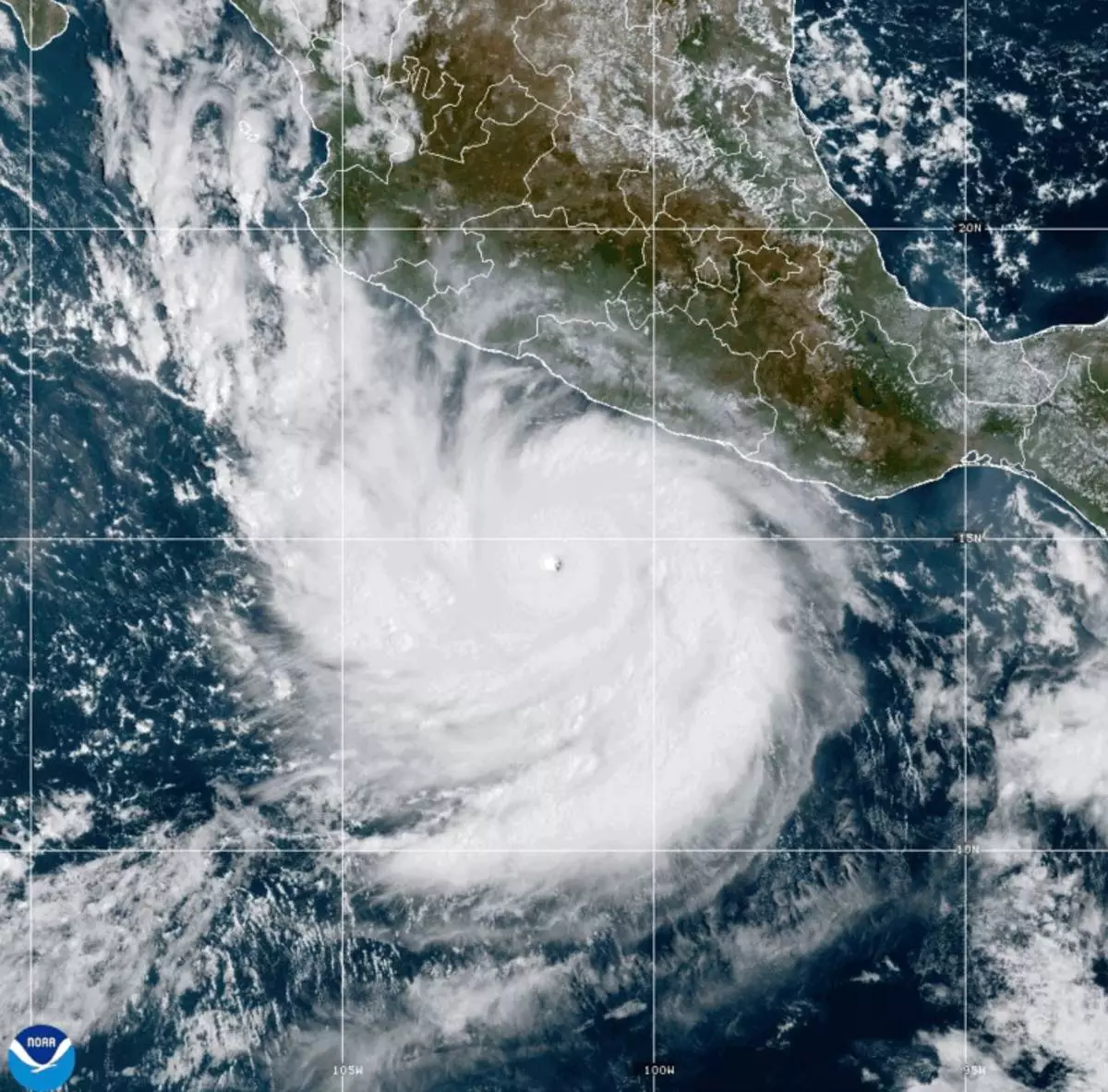
This photo provided by NOAA shows Hurricane Polo strengthening in the Pacific Ocean off the coast of Mexico on Tuesday, Sept. 22, 2026. (NOAA via AP)
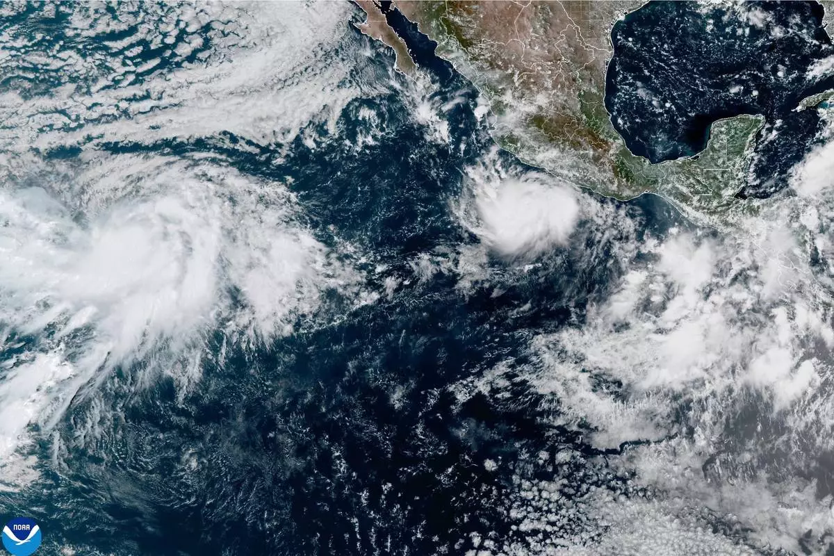
This photo provided by NOAA shows Hurricane Polo intensifying in the Pacific Ocean off the coast of Mexico on Monday, Sept. 21, 2026. (NOAA via AP)