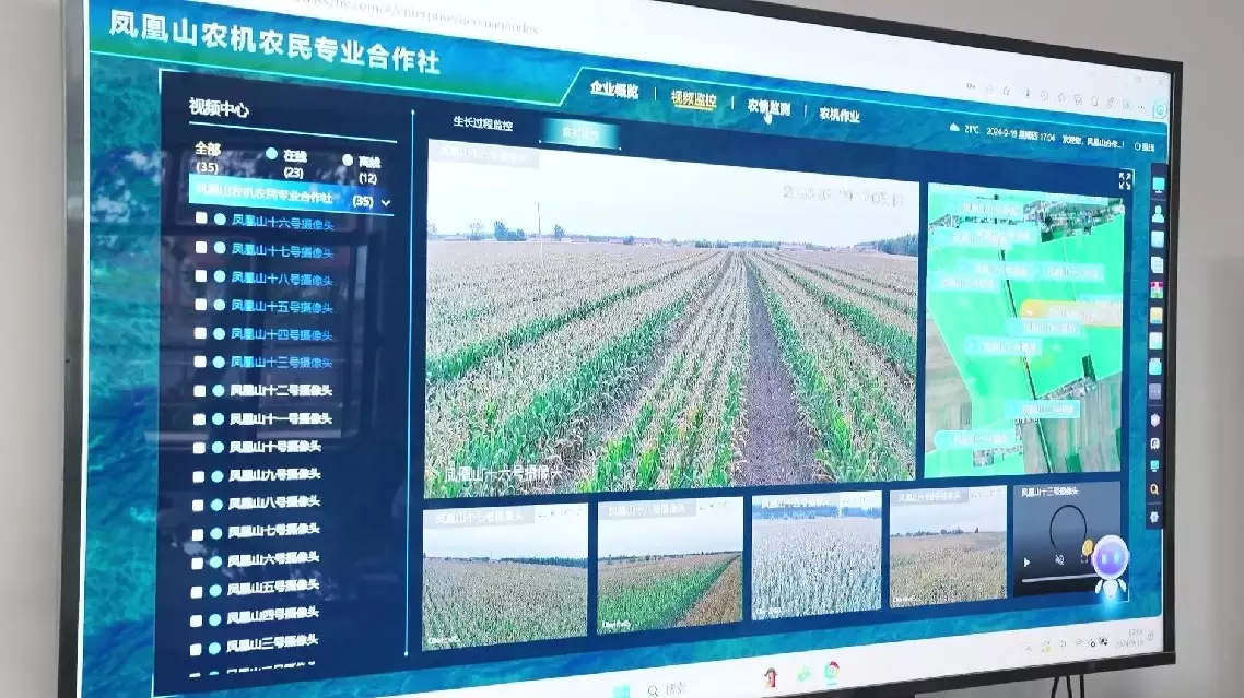
Satellite technology supports Lishu County, a major grain producing county in northeast China's Jilin Province, in increasing food supply and safeguarding food security through real-time data on farmlands, including alerts for pests and diseases, soil moisture, and crop growth, thus propelling significant advancements in agricultural modernization within the county. In Lishu, farmers are embracing the harvest season. In the past, they relied on scarecrows and manual labor to protect crops from birds and pests, but today, they have freed their hands thanks to high-tech assistance from space. "Our technology is from the sky and the satellites. Look at this big screen, in the middle is our cooperative which now has 24 such monitoring stations you just saw. On the monitoring platform, you can see the situation of any parts of the land and its situation, you can click on whose land this belongs to, what situation is convenient for us to operate. This part of the base station is to monitor the insect situation and there are parts to monitor the wind, humidity, and so on. This basement is the connection point between the outer space and the surface farmland and is also the modern 'bodyguard' of our farmland," said Han Fengxiang, head of an agricultural machinery and farmers specialized cooperative in the county. "This part of the base station is to monitor the insect situation and there are parts to monitor the wind, humidity, and so on. This basement is the connection point between the outer space and the surface farmland and is also the modern 'bodyguard' of our farmland," she said. The remote monitoring data utilized in Lishu comes from the Jilin-1 satellites, which provide data and services for agriculture, forestry, resources and the environment. Through these satellites, farmers receive real-time farmland data via satellite imagery, including soil moisture, crop growth, and pest and disease alerts. This helps in precise fertilization, irrigation and pest control, ultimately enhancing crop yield and quality. "This is our remote sensing monitoring platform for Lishu County. We can monitor various aspects of farmland, such as moisture content, growing and disasters situation and it can estimate the yield more accurately, which is of great help to the macroeconomic aspects such as national grain reserves and grain futures," said Qu Chunmei, director of the third data center office of Chang Guang Satellite Technology, a Chinese commercial satellite company. "We have initially formed a 'fingertip agriculture' right now, with the current science and technology belongs to the integration of space and industry, with the increase in the number of our satellites, there will be more data in the future to remotely monitor the soil nutrient content and others to promote the iteration and progress of smart agriculture," said Wang Guiman, head of the agricultural technology promotion station in Lishu.
Satellites help China's grain producing county safeguard food security, advance agricultural modernization