U.S. President Donald Trump said on Friday that Washington had agreed to continue negotiations with Iran, although it had informed Tehran that the ceasefire was over.
"The Islamic Republic of Iran has asked us to continue 'talks.' We have agreed to do so, but the United States has stated to them, in no uncertain terms, that the Cease Fire is OVER!" Trump wrote on Truth Social.
Qatari negotiators have traveled to Iran after coordinating with the Trump administration in an effort to de-escalate tensions and revive the U.S.-Iran talks, CNN reported Friday, citing a diplomat familiar with the effort.
A new round of U.S.-Iran negotiations is expected to be held next week, possibly in Switzerland, according to a report from U.S. media outlet Axios, citing a source with knowledge of the matter.
Later the same day, U.S. Central Command spokesperson Tim Hawkins said there were "no operational updates" following Trump's announcement that the ceasefire was over.
Asked whether the end of the ceasefire would lead to a resumption of airstrikes, Hawkins said he would not speculate about future operations.
U.S. forces in the region will "remain vigilant, lethal, and prepared to execute operations directed by the Commander in Chief," he said.
Despite the diplomatic moves, the United States launched airstrikes on several cities in southern Iran on Wednesday and Thursday, and targeted two railway bridges in northeastern Iran, saying the attacks were in response to "Iran's latest attacks on commercial vessels transiting the Strait of Hormuz."
In addition, 30 fishing boats in south Iran's Bandar Abbas port were destroyed by U.S. strikes in the past two days, according to a Friday report by Iranian media.
Mohammad Bagher Zolghadr, secretary of Iran's Supreme National Security Council warned Friday that Iran will retaliate against any attack on its infrastructure, and that Israel will not be spared from its response.

Trump says US-Iran talks to continue but ceasefire is over
A documentary has revealed how generations of fishermen in south China's Hainan Province navigated the South China Sea for centuries with no GPS, no weather forecasts, relying only on a handwritten manual known as the Genglubu.
The documentary, Genglubu: Charting the South China Sea, premiered Thursday on China Global Television Network (CGTN).
Unintelligible to outsiders, the Genglubu was an invaluable navigational guide for fishermen and one of the most important items they carried on board.
"What Tanmen fisherman do is dive into the sea and catch fish ourselves. Finding better reefs means catching more fish. And that's why we keep going back to the South China Sea. My grandfather and father would study it like homework before setting out," said Wang Zhendong, curator of the Genglubu Museum in Hainan's Qionghai City.
Wang cannot personally interpret the old manuscript, but he understands its importance: his father studied it before every voyage, and his grandfather trusted it with his life.
"When electronic equipment fails, if you don't understand navigation, how are you going to bring everyone home safely? A captain needs to understand experience. So where does that experience come from? It comes from the Genglubu. It's the ancient knowledge recorded generation after generation," said Wang Shubao, Wang Zhendong's father.
Over generations, that knowledge was written down in the Genglubu.
"Geng" referred to both time and distance traveled at sea. One "geng" was about two hours of sailing, or roughly 10 nautical miles.
"Lu" referred to compass bearings and direction, while "bu" meant "book."
Without modern instruments, fishermen learned to read the sea -- its currents, its depths, its changing moods.
Knowledge shaped their navigation. The Genglubu recorded that knowledge.
One line in it says: From Tanmen port to the Xisha Islands' Zhaoshu (Paracel's Tree Island), follow the direction of the Qian, Sun, which is northwestward. It covers a distance of some 150 nautical miles.
Just a few lines, enough to guide a boat across open water.
One surviving manuscript, copied by Wang Shitao, records 279 routes, making it one of the most detailed versions of the Genglubu known today. Its routes link Hainan with island groups across the South China Sea, with some extending even farther.
"Before Zheng He's voyages (1405-1433) to the Western Seas, the fishermen had already been working these waters of the South China Sea," said Zhou Weimin, a professor at Hainan University.
Experts say the Genglubu is more than a practical guide to navigation; it is also a record of China’s maritime history, cultural heritage and the accumulated wisdom of a people shaped by the sea.
"The Genglubu is a navigation handbook born of experience accumulated through long-term practice. It forms an integral part of China's maritime system. It is a cultural legacy created by our ancestors and a crystallization of the wisdom of a people with a long maritime tradition," said Liu Yijie, a professor at the Center for Studies of Fujian and Taiwan at Fujian Normal University.
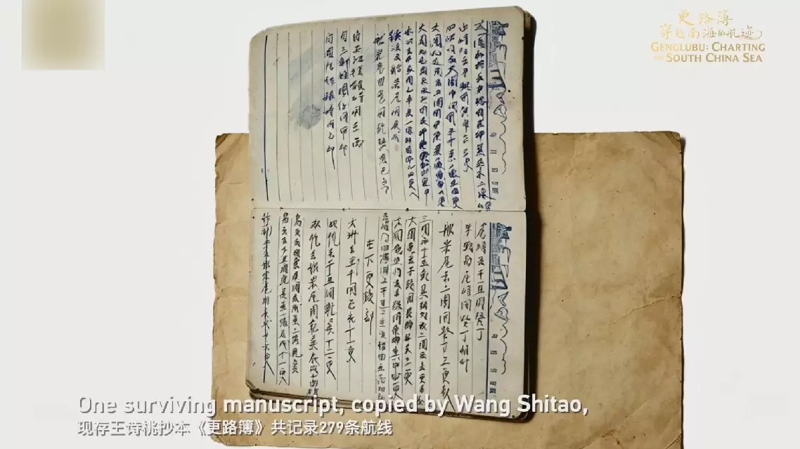
Documentary decodes Genglubu - South China Sea's ancient GPS