IRVINE, Calif.--(BUSINESS WIRE)--Nov 4, 2026--
Homes in Louisiana are more exposed to extreme weather than anywhere else in the U.S., according to new Cotality research ranking the highest- and lowest-risk states.
This press release features multimedia. View the full release here: https://www.businesswire.com/news/home/20261104543775/en/
Ranking all U.S. states by the severity of weather perils to property, the analysis reveals that average annual losses (AAL) are projected to rise sharply by 2050 in the highest- and lowest-risk states alike. Flooding, hurricanes and severe convective storms are set to drive the largest losses.
Hurricanes, floods and hail: inside the 10 riskiest states
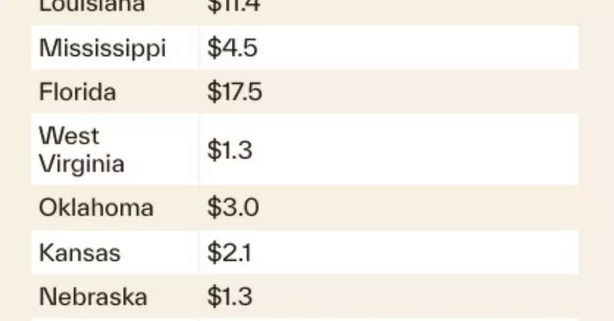
Louisiana ranks as the highest-risk state, with damages from all weather perils costing $6.7 billion in AAL. Hurricane wind is currently the state’s costliest peril, but Cotality projects inland flooding will overtake it by 2050, at an estimated $3.8 billion in AAL. Average annual losses from all perils are projected to rise 70.3% to $11.4 billion.
Mississippi and Florida rank second and third, driven by exposure to hurricane winds. Hurricane wind is expected to remain the top peril in both states through 2050, with losses set to rise sharply. Florida’s losses from all perils is projected to jump 62.3%, from $10.8 billion in AAL today to $17.5 billion in 2050. Mississippi’s is set to rise 54.1% over the same period, from $2.9 billion to $4.5 billion.
West Virginia ranks fourth, driven by inland flooding, with an estimated $989 million in AAL - a substantial burden for a state with roughly 900,000 homes. Oklahoma, Kansas, Nebraska, Texas, Alabama and Missouri complete the top 10.
“When people think of extreme weather, they usually think of places like California, Texas and Florida, but the most severe concentrations of risk aren’t always where you’d expect,” said Dr. Howard Botts, Chief Scientist at Cotality. “West Virginia doesn’t have headline-grabbing hurricanes or wildfires, but its topography leaves it highly exposed. Much of its housing sits in mountain valleys, so as the region gets wetter, flood risk is rising sharply.”
In the safest states, losses are still climbing
The District of Columbia ranks as the lowest-risk of any state or district, with $31 million in AAL from all weather perils combined. Pennsylvania ranks second-lowest, followed by Maryland, Michigan and Virginia. Across the 10 lowest-risk states, the leading perils are severe convective storms, severe winter storms and inland flooding. Oregon is the exception, with earthquakes as its top peril.
Combined, the 10 lowest-risk states face $10.9 billion in AAL from all perils - roughly the same as Florida alone, at $10.8 billion.
“It’s important to remember that ‘low risk’ doesn’t mean ‘no risk’,” said Botts. “Every state has its own mix of perils and resilience, but wherever a state lands in our ranking, weather losses are projected to rise.”
While Maryland ranks as the third lowest-risk state today, its average annual losses are projected to rise 50.4% by 2050, from $609 million to $916 million. Across the 10 lowest-risk states, losses are projected to increase by 37.9% on average - not far behind the 46.7% average for the 10 highest-risk states.
California and Texas have the most homes on the line
When assessing the number of homes at risk in each state, California tops the list with 10.4 million homes and $18.9 billion in AAL. Earthquakes are California’s leading peril, followed by wildfire and inland flooding. The state’s wildfire losses are projected to nearly double by 2050, from $2.9 billion to $5 billion.
Texas ranks second by this measure, with $11.5 billion in AAL across 10.4 million homes. Hurricane wind, hurricane flooding and inland flooding are currently its costliest perils. By 2050, Cotality projects severe convective storms will take the top spot, at an estimated $7.4 billion in AAL - nearly two-thirds of the state’s current losses from all perils.
“State-level rankings offer a topline view, but when it comes to understanding and mapping risk, the detail matters,” added Botts. “To know what communities really face, insurers, lenders and policymakers need data at the county, ZIP code and property level. Local conditions can dramatically change the shape of risk, and pricing that reflects each property’s vulnerabilities helps ensure capital is in place before disaster strikes.”
Notes to editor
U.S. states are ranked using Cotality’s proprietary risk scoring model, which evaluates the severity and likelihood of weather perils using a 1-100 scale. Risk is assessed and scored as it threatens property, as opposed to non-populated areas.
About Cotality
Cotality accelerates data, insights, and workflows across the property ecosystem to enable industry professionals to surpass their ambitions and impact society. With billions of data signals across the life cycle of a property, we unearth hidden risks and transformative opportunities for agents, lenders, carriers, and innovators. Get to know us at cotality.com.
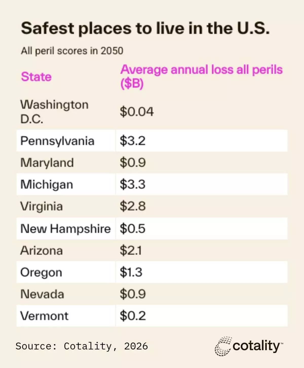
The safest U.S. states for natural hazards in 2050, ranked by Cotality all-peril scores, with projected average annual losses in billions.
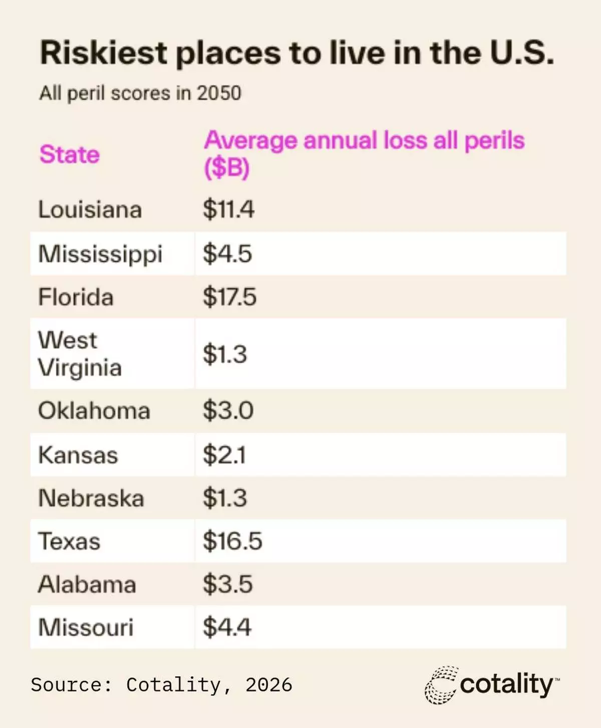
The riskiest U.S. states for natural hazards in 2050, ranked by Cotality all-peril scores, with projected average annual losses in billions.
Investigators are just beginning the lengthy process of determining why a business jet plummeted from the sky in Florida after encountering a thunderstorm and slammed into the ground with such force that it created a crater and shattered the plane.
The National Transportation Safety Board is leading the investigation into the crash that killed all nine people aboard the Bahamas-bound Learjet, and it will likely take more than a year to determine the cause.
Dramatic bystander videos combined with the the disturbing final radio transmissions as the pilots realize their fate will give investigators important clues. The cockpit voice recorder would also help if investigators can find it intact.
“Our mission is to understand not just what happened, but why it happened, and to recommend changes to prevent it from happening again,” NTSB member Tom Chapman said.
Here's what investigators are doing now and what comes next:
The NTSB team will spend days collecting every piece of the plane they can find. Investigators said Tuesday that pieces of a key part of the tail called the elevator, which controls the plane's pitch, were found more than a mile away from the main crater. That confirms the plane started to break apart before impact.
Chapman said investigators are searching for the Learjet's cockpit voice recorder because it could provide crucial details about what the pilots said to each other as they encountered turbulence, ice formed on the wings and they lost control of the aircraft.
“That will be very important data,” Chapman said. But being unable to find that recorder won't doom the investigation. “Without it, our folks are very, very good. We’re still able to do some incredible detective work and determine how things transpired.”
The co-pilot told air traffic controllers that the plane was being thrown up and down more than 700 feet (213 meters) and she asked them for a better route through the area. It's not clear why the pilots didn't fly around the storms.
Torrential rains in Florida over the past week have hindered the investigators' work. The crater filled with rainwater, possibly concealing parts of the wreckage under water, and a utility pole had to be removed.
The NTSB asked anyone who finds part of the plane to report that to investigators to collect.
The agency’s findings so far are limited, but its experts will publish a preliminary report describing the facts of what happened about 30 days after the crash. It won’t include analysis or cause, which will come in a later more detailed report.
The force of the crash and the fire destroyed much of the plane. Any evidence investigators are able to gather will be taken to a secure hangar where they can test or try to reassemble smashed components to better understand what happened.
Retired airline pilot and aviation safety expert John Cox said he doesn’t understand why the plane descended from its cruising altitude of 41,000 feet (12,500 meters) as it approached the storms. The pilots steered around a larger storm cell but appeared to head directly into a rapidly developing smaller one, Cox said.
“If I’m looking at thunderstorms, I’d rather be at 41 than at 35. You’ve got a better view, you’re more likely to be on top of it, or at least, in the very wispy tops of it,” Cox said. “I don’t understand why they came down.”
Investigators will try to determine whether they knew that storm cell was there, what the plane’s weather radar showed and whether the pilots checked any other weather services.
Weather will be a key early focus of the investigation. NTSB experts will work with the National Weather Service and the Federal Aviation Administration to get a better idea of what the plane encountered at around 35,000 feet (11,000 meters).
Images that overlay the flight path atop weather radar maps show the Learjet flew directly into a small red storm cell that quickly worsened.
But the agency will consider a myriad of factors that may have contributed to the crash.
Investigators will review maintenance records and any history of problems with the plane. They will also interview officials at Upper Jets, the company that operated the flight, as well as air traffic controllers and people who work at the airport in Austin, Texas, from where the plane departed.
Videos and photos shot by bystanders can also provide crucial clues about what happened. The NTSB will also collect surveillance footage that might show the crash.
In certain high-profile crashes, the NTSB can hold investigative hearings during which investigators question people, as it did after last year's UPS plane crash.
Generally, it takes 12 to 18 months for the NTSB to complete a crash investigation, but complicated cases can take longer. NTSB's roughly 400 workers are pursuing more than 1,200 active investigations.
Final reports include extensive details about what happened and identify the probable causes.
The NTSB recommends changes to prevent similar crashes and improve safety, but it doesn't have the power to require those changes to be installed or enforced.
The responsibility for adopting those falls to the FAA, the industry and Congress, all of whom have historically ignored NTSB recommendations, deeming such changes too costly and cumbersome.
Even when the FAA or Congress agree with the suggestions it can take years to approve new rules.
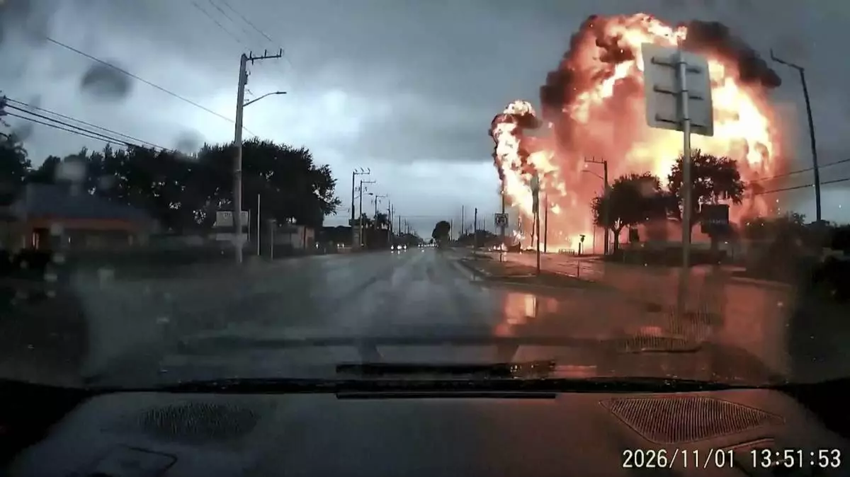
This image taken from Aki Kuusisto's video shows a small jet crashing in Palm Beach County, Fla., on Sunday, Nov. 1, 2026. (Aki Kuusisto via AP)

Investigators work at the scene of a plane crash in Greenacres, Fla., Monday, Nov. 2, 2026. (AP Photo/Rebecca Blackwell)