East China's Fujian Province has implemented multiple emergency measures to prepare for Typhoon Bavi, the ninth typhoon of 2026, which is expected to bring strong winds and heavy rain.
Fujian upgraded its typhoon alert to Level II at 16:30 on Friday after Bavi entered the province's tropical cyclone warning zone.
The provincial flood control and drought relief headquarters ordered local authorities to closely monitor the typhoon’s movement, adjust response measures as necessary, and evacuate people from high-risk areas in a decisive and orderly manner to ensure public safety.
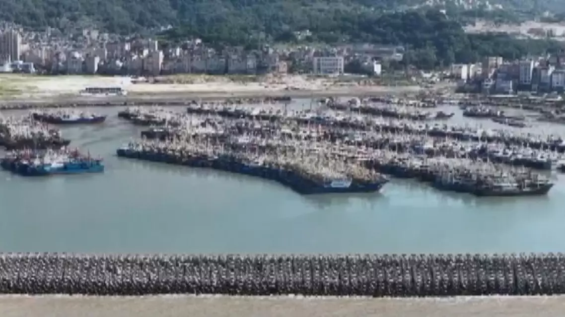
As part of its emergency response, the province has evacuated residents to safe areas, recalled fishing boats to port, and suspended passenger ferry services.
Ningde, a major aquaculture base in Fujian, lies within the area expected to be affected by the typhoon. Local aquaculture workers have reinforced fish rafts ahead of the storm to prevent them from shifting or sustaining damage and to minimize fish losses.
Offshore cabins have also been moved to sheltered areas, while aquaculture operations near Dawan Village in Ningde City have been suspended.
"Every typhoon season, we stay on alert. This time, the warning came early, so we moved fast to secure the rafts and bring the equipment ashore. It’s extra work, but it’s better than taking risks. We just want to protect our fish and keep losses to a minimum," said Huang Zuhua, an aquaculture farmer in Ningde.
"Our main tasks today are to remove six wind turbines, reinforce the solar panels, disconnect some cable terminals, and secure the fish-raft cabins. We also need to tow the cabins to anchor points to minimize the typhoon’s impact on the fish rafts," said Yang Jun, a worker with the State Grid Ningde Power Supply Company.
"We were worried strong winds could damage the cabins, so we towed them closer to shore early. If the cabins and boats were left on the rafts, big waves could knock them around and cause damage," said Guo Zhongliang, another aquaculture farmer in Ningde.
Xiapu County in Ningde has stepped up efforts to reinforce marine aquaculture facilities over the past two days. Local authorities have also organized the return of fishing boats to port and the orderly evacuation of offshore workers.
In accordance with Ningde’s typhoon-prevention requirements, more than 11,700 people working on aquaculture rafts had come ashore by noon on Friday, while more than 34,500 vessels had reached safe waters.
As a precaution, coastal ports across the province suspended cruise ship arrivals and halted all recreational vessel operations.
As of 11:00 on Friday, a total of 66 coastal passenger ferry routes and 139 passenger ferries had been suspended, according to the Fujian maritime bureau. Authorities also ordered all 110 marine construction projects underway along the coast and 14 offshore wind farms to halt operations.
China has a four-tier typhoon emergency response system, with Level I representing the highest level of severity.
Fujian steps up emergency measures ahead of Typhoon Bavi
A documentary has revealed how generations of fishermen in south China's Hainan Province navigated the South China Sea for centuries with no GPS, no weather forecasts, relying only on a handwritten manual known as the Genglubu.
The documentary, Genglubu: Charting the South China Sea, premiered Thursday on China Global Television Network (CGTN).
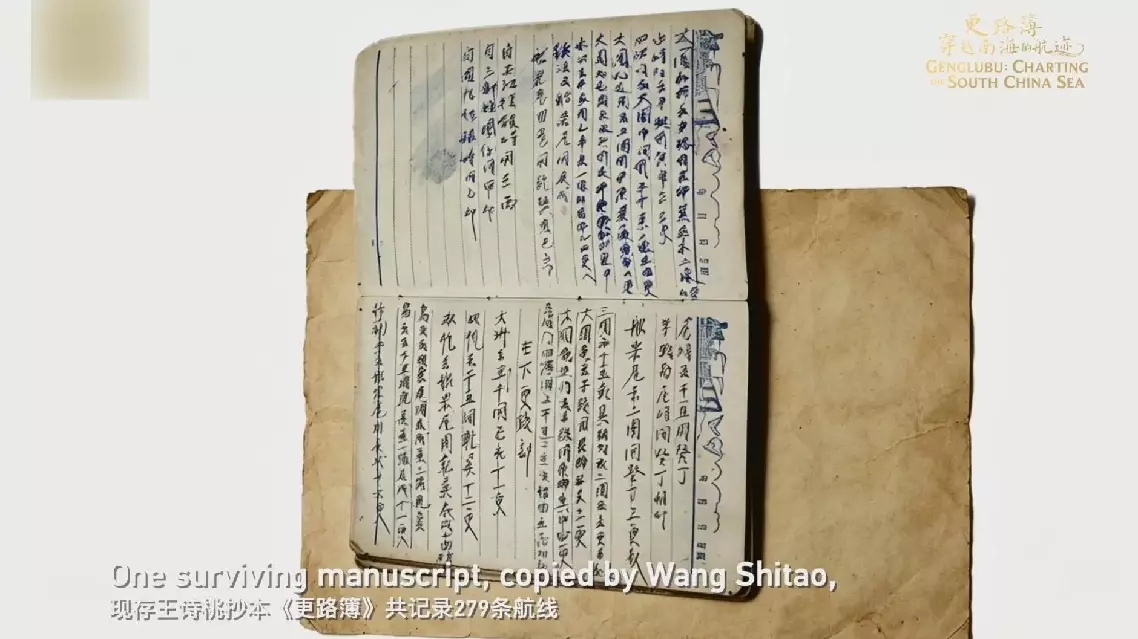
Unintelligible to outsiders, the Genglubu was an invaluable navigational guide for fishermen and one of the most important items they carried on board.
"What Tanmen fisherman do is dive into the sea and catch fish ourselves. Finding better reefs means catching more fish. And that's why we keep going back to the South China Sea. My grandfather and father would study it like homework before setting out," said Wang Zhendong, curator of the Genglubu Museum in Hainan's Qionghai City.
Wang cannot personally interpret the old manuscript, but he understands its importance: his father studied it before every voyage, and his grandfather trusted it with his life.
"When electronic equipment fails, if you don't understand navigation, how are you going to bring everyone home safely? A captain needs to understand experience. So where does that experience come from? It comes from the Genglubu. It's the ancient knowledge recorded generation after generation," said Wang Shubao, Wang Zhendong's father.
Over generations, that knowledge was written down in the Genglubu.
"Geng" referred to both time and distance traveled at sea. One "geng" was about two hours of sailing, or roughly 10 nautical miles.
"Lu" referred to compass bearings and direction, while "bu" meant "book."
Without modern instruments, fishermen learned to read the sea -- its currents, its depths, its changing moods.
Knowledge shaped their navigation. The Genglubu recorded that knowledge.
One line in it says: From Tanmen port to the Xisha Islands' Zhaoshu (Paracel's Tree Island), follow the direction of the Qian, Sun, which is northwestward. It covers a distance of some 150 nautical miles.
Just a few lines, enough to guide a boat across open water.
One surviving manuscript, copied by Wang Shitao, records 279 routes, making it one of the most detailed versions of the Genglubu known today. Its routes link Hainan with island groups across the South China Sea, with some extending even farther.
"Before Zheng He's voyages (1405-1433) to the Western Seas, the fishermen had already been working these waters of the South China Sea," said Zhou Weimin, a professor at Hainan University.
Experts say the Genglubu is more than a practical guide to navigation; it is also a record of China’s maritime history, cultural heritage and the accumulated wisdom of a people shaped by the sea.
"The Genglubu is a navigation handbook born of experience accumulated through long-term practice. It forms an integral part of China's maritime system. It is a cultural legacy created by our ancestors and a crystallization of the wisdom of a people with a long maritime tradition," said Liu Yijie, a professor at the Center for Studies of Fujian and Taiwan at Fujian Normal University.
Documentary decodes Genglubu - South China Sea's ancient GPS