Skip to Content Facebook Feature Image

onWater Fish App Launches Next-Gen Tools to Power the Future of Angling

News

onWater Fish App Launches Next-Gen Tools to Power the Future of Angling
News

News

onWater Fish App Launches Next-Gen Tools to Power the Future of Angling

2025-06-02 18:01 Last Updated At:18:10

BOULDER, Colo.--(BUSINESS WIRE)--Jun 2, 2025--

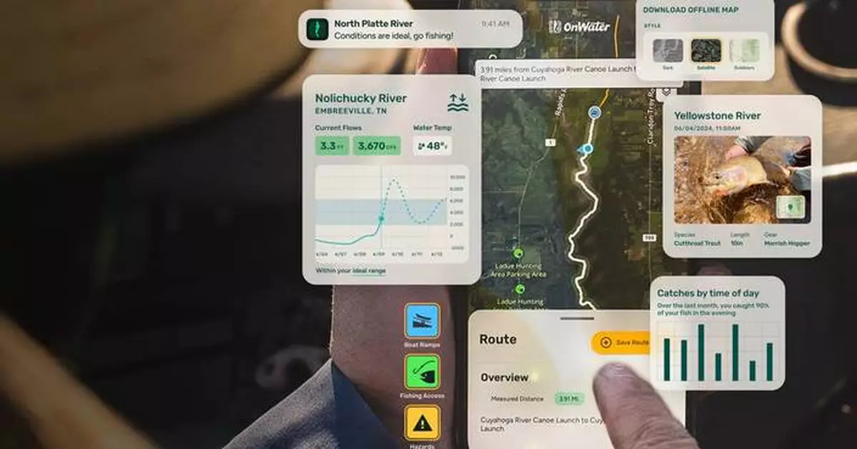
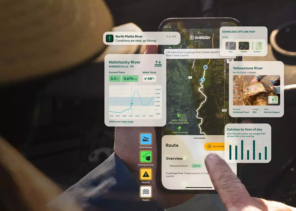
onWater Fish, the leading app for anglers and water-based exploration, today launched their Summer 2025 update with a suite of next-gen tools designed to help users better understand their fishing patterns, make more informed decisions on the water, and support conservation efforts. The trio of enhancements include a smart Journal, a patented AI Trout Measuring Tool, and a MyWaters feature for personalized insights that include notifications when conditions align with past fishing success. These new and improved features are part of onWater’s growing suite of tools built to power the future of fishing.

This press release features multimedia. View the full release here: https://www.businesswire.com/news/home/20250602251753/en/

“The way anglers connect with nature is evolving,” said Alex Maier, CMO and Head of Product at onWater. “Our goal is to give users access and insights in the form of real-time environmental data, AI analysis, and personal performance tracking so they can become smarter and more environmentally conscious anglers.”

A Smarter Fishing Journal

onWater’s enhanced Journal feature will give anglers a deeper look into their fishing habits and outcomes. With the updated Journal, anglers can now:

“Imagine opening your dashboard and instantly seeing the best river flows, the perfect fly pattern for the day, and the ideal time to cast,” said Maier. “You’ll have access to everything you need, dialed by data, so all that’s left is the thrill of the catch.”

AI Fish Measuring That Protects the Catch

onWater’s patented AI Trout Measuring Tool, launching in beta, gives anglers an accurate, hands-off way to log their catches. The new tool protects fish health while improving data collection with:

Angling with Insight, Not Guesswork

Unlike other fishing apps that contribute to spot burning, onWater is built to help individual anglers fish smarter. Instead of revealing exact catch locations to all users, it empowers each fisher to understand the why behind their great days on the water.

With a new “MyWaters” tool, anglers can monitor their favorite spots. The app delivers personalized alerts when conditions in those waters align with those of past successes, helping you know the right where, when, and how to fish, without compromising your spots through public sharing.

Leveraging scientific data such as fish metabolic rates and water temperatures across every body of water in the United States, MyWaters works alongside the enhanced Journal to increase your chances of success. The more you fish, the more insights you gain.

Discovery Tools and Public Access

In addition to its journal and insights capabilities, onWater offers a robust discovery experience with detailed data on more than 430,000 U.S. water bodies, including:

onWater sees angler empowerment and conservation as two sides of the same coin. With high engagement across both free and paid users, the platform is built to modernize the angling experience while also promoting responsible recreation and environmental stewardship.

About onWater

onWater is a modern fishing app that helps anglers discover and access fishing waters, log their trips, and gain powerful insights from their activity. Built by anglers, for anglers, onWater combines cutting-edge technology with a commitment to conservation and education. Download onWater in the App Store or head to OnWaterApp.com to learn more.

“Imagine opening your dashboard and instantly seeing the best river flows, the perfect fly pattern for the day, and the ideal time to cast,” said onWater CMO Alex Maier. “You’ll have access to everything you need, dialed by data, so all that’s left is the thrill of the catch.”

“Imagine opening your dashboard and instantly seeing the best river flows, the perfect fly pattern for the day, and the ideal time to cast,” said onWater CMO Alex Maier. “You’ll have access to everything you need, dialed by data, so all that’s left is the thrill of the catch.”

BISMARCK, N.D. (AP) — Federal officials on Thursday gave final approval for the Dakota Access oil pipeline to continue operating its contentious Missouri River crossing, an outcome that comes nearly a decade after boisterous protests against the project on the North Dakota prairie.

The U.S. Army Corps of Engineers’ decision to grant the key easement means the pipeline will keep operating but with added conditions for detecting leaks and monitoring groundwater, among others. The announcement brings an end to a drawn-out legal and regulatory saga stemming from the protests in 2016 and 2017, though further litigation over the pipeline is likely.

The $3.8 billion, multistate pipeline has been transporting oil since June 2017 from North Dakota’s Bakken oil field to a terminal in Illinois. The line carries about 4% of U.S. daily oil production, or roughly 540,000 barrels per day,

The Corps is “decisively putting years of delays to rest and moving out to safely execute this crossing beneath Lake Oahe," Assistant Secretary of the Army for Civil Works Adam Telle said in a statement.

The pipeline crosses the river upstream from the Standing Rock Sioux Tribe’s reservation, which straddles the Dakotas. The tribe has long opposed the pipeline, fearing a spill and contamination of its water supply. In 2016 and 2017, thousands of people camped and protested for months near the river crossing.

The protests resulted in hundreds of arrests and related criminal cases and lawsuits, some of them still ongoing, including litigation that threatens the future of the environmental group Greenpeace.

In December, the Corps released its final environmental impact statement nearly six years after a federal judge ordered a more rigorous review of the pipeline's crossing. In that document, the Corps endorsed the option to grant the easement for the crossing and keep the pipeline operating with modifications.

Those measures include enhanced leak detection and monitoring systems, expanded groundwater and surface water monitoring and third-party expert evaluation of the leak and detection systems, among others, the Corps said. The conditions also include water supply contingency planning and other studies coordinated with affected tribes.

The Corps had weighed several options, including removing or abandoning the pipeline's river crossing or even rerouting it north. The agency said its decision “best balances public safety, protection of environmental resources, and leak detection and response considerations while meeting the project’s purpose and need.”

Pipeline developer Energy Transfer hailed the decision, saying the pipeline has been safely operating for nearly 10 years and is critical to the country’s energy infrastructure.

“We want to thank the Corps for the tremendous amount of time and effort put in by so many to bring this matter to a thoughtful close,” said Vicki Granado, a company spokesperson.

The Associated Press sent text messages and emails to media representatives for the tribe and left a voicemail at the tribe's headquarters. They didn't immediately respond Thursday.

North Dakota Republican Gov. Kelly Armstrong, Interior Secretary and former North Dakota governor Doug Burgum and U.S. Senators John Hoeven and Kevin Cramer each welcomed the decision to ensure the pipeline continues operating.

The Corps' announcement came as officials and oil industry leaders were gathered for a trade conference in Bismarck.

Energy Transfer and Enbridge are in early stages of a project to move about 250,000 daily barrels of light Canadian crude oil through the Dakota Access Pipeline by using another pipeline and building a 56-mile connecting line, spokespersons for the companies said. Enbridge will decide sometime in mid-2026 whether to move ahead.

FILE - A sign for the Dakota Access Pipeline is seen north of Cannonball, N.D. and the Standing Rock Reservation on May 20, 2021. (AP Photo/Matthew Brown, File)

FILE - A sign for the Dakota Access Pipeline is seen north of Cannonball, N.D. and the Standing Rock Reservation on May 20, 2021. (AP Photo/Matthew Brown, File)

Recommended Articles