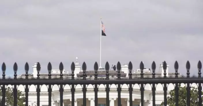
H
O
T
O
T
China's new trade-in program sparks consumption boom
A new round of trade-in subsidy program is energizing China's consumer market these days, with provinces across the country seeing a surge in demand for cars, home appliances and digital devices.

China's new trade-in program sparks consumption boom

Iranians in China hope for quick resolution to unrest, urge against foreign interference
Hong Kong and Mainland China Strengthen Healthcare Collaboration with New Agreements on Chinese Medicine and Cancer Prevention.

Chinese FM says it's opportune time for China, AU to enhance strategic mutual trust, cooperation
Iranians in China hope for quick resolution to unrest, urge against foreign interference
Hong Kong and Mainland China Strengthen Healthcare Collaboration with New Agreements on Chinese Medicine and Cancer Prevention.
Chinese FM says it's opportune time for China, AU to enhance strategic mutual trust, cooperation
Feature · News

Internet services partially resume, sufficient daily supplies available in Iran's Tehran

China aims for full zero-waste city coverage by 2035

Economy remains primary issue as presidential election draws close in Uganda

Microsoft's Brad Smith pushes Big Tech to 'pay our way' for AI data centers amid rising opposition
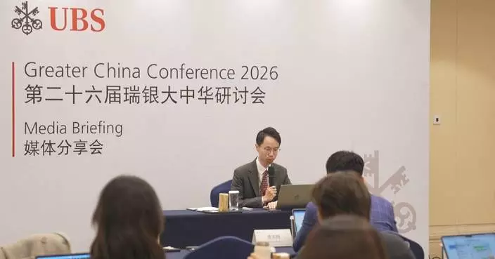
UBS forecasts 8 pct growth in China's equity market for 2026

China extends anti-dumping tariffs on solar-grade polysilicon imports from US, ROK

BP China Insight : Trump's Actions Have Turned the EU into an Outdated Relic of History

BP China Insight : Beijing Strikes Back at Meta's "Grab Tech and Talent" Acquisition

Here's how AP reports on the death toll from Iran's protests

China to increase support for elderly care service providers
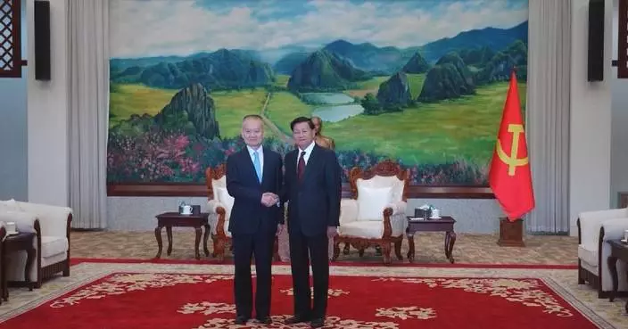
Xi's special envoy visits Laos

Reliance Matrix Elevates Customer Experience Strategy with Leadership Appointment

Court Dismisses Chow Hang Tung's Challenge to Hong Kong's Clothing Policy for Persons in Custody

Heavy snowfall blankets Serbia, disrupting power supply, transportation

Severe pediatric influenza case prompts urgent vaccination reminder from health authorities.

New 468 Employment Rule Enhances Part-Timer Rights, Effective January 18, Says Labour Secretary Chris Sun.
BP China Insight : Trump's Actions Have Turned the EU into an Outdated Relic of History
BP China Insight : Beijing Strikes Back at Meta's "Grab Tech and Talent" Acquisition
Here's how AP reports on the death toll from Iran's protests
China to increase support for elderly care service providers
Internet services partially resume, sufficient daily supplies available in Iran's Tehran
China aims for full zero-waste city coverage by 2035
Economy remains primary issue as presidential election draws close in Uganda
Microsoft's Brad Smith pushes Big Tech to 'pay our way' for AI data centers amid rising opposition
UBS forecasts 8 pct growth in China's equity market for 2026
China extends anti-dumping tariffs on solar-grade polysilicon imports from US, ROK
Xi's special envoy visits Laos
Reliance Matrix Elevates Customer Experience Strategy with Leadership Appointment
Court Dismisses Chow Hang Tung's Challenge to Hong Kong's Clothing Policy for Persons in Custody
Heavy snowfall blankets Serbia, disrupting power supply, transportation
Severe pediatric influenza case prompts urgent vaccination reminder from health authorities.
New 468 Employment Rule Enhances Part-Timer Rights, Effective January 18, Says Labour Secretary Chris Sun.
Feature·Bloggers

【What Say You?】Accomplice Witness Chen Zihao: Family Stalked, Fears Black Bloc Revenge After Release

【Deep Blue】International Laws? You Kidding Me?

【Bastille Commentary】Chicken-hearted Conservatives: Sanctioning Hong Kong Judges While Trump Runs Wild

【What Say You?】Trump’s “Maduro Grab” Gets a Glossy Spin by the Usual Suspects

【What Say You?】Trump's Judicial Theater: Maduro's Fate Already Sealed

【Deep Throat】Trump's Venezuelan Oil Grab: Big Oil Not Playing Along?

NYC Council employee’s arrest sparks protests and a dispute over his immigration status
- Justice Department sees no basis for civil rights probe in Minnesota ICE shooting, official says
- Trump calls on Tehran to show protesters humanity amid reports of rising death toll in crackdown
- The Latest: Trump lashes out at Federal Reserve in speech to Detroit Economic Club
- 'West Wing' actor Timothy Busfield turns himself in to face child sex abuse charges in New Mexico
- Rio de Janeiro zoo animals are treated to popsicles as the city faces scorching summer weather
- Georgia lawmakers move to strike Savannah ban on guns in unlocked cars
- Democrats will spend millions to shift voter registration strategy ahead of the midterm elections
- Veracity Launches Metabolic Power Protein: A Smarter Protein Designed to Strengthen Your Metabolism Without Toxicity
- National Board of Review to fete 'One Battle After Another.' Here's how to watch stars' arrivals

China's Long March-8A rocket launches new satellite group
- Chang'e-6 lunar sample unveils key clues to moon's geological evolution
- China flu activity declines for fourth week, no new pathogens detected: official
- Internet blackout adds to Iran tensions: CGTN correspondent
- Chinese commerce chambers welcome latest development in China-EU EV talks
- China opens 2026 space mission schedule with successful satellite launch
- Palestinian death toll in Gaza rises to 71,424: health authorities
- China's box office revenue for commercial performances hits 61.66 bln yuan in 2025
- Iranians in Türkiye return home, fearing for their families amid unrest in Iran
- US, Iran must rebuild trust before diplomacy can succeed: expert

NLCS (Singapore) Brings World-Class Musical Opportunities to Young Artists Across Asia
- Wall Street executives warn Trump: Stop attacking the Fed and credit card industry
- Hospital and nurses fail to negotiate during second day of NYC's largest nursing strike in decades
- GIGABYTE Redefines Human-AI Interaction at CES 2026 with a Fully Immersive, Participatory Experience
- Detroit Auto Show opens as industry pares back splashy debuts and leans on test tracks
- Trump visits a Ford pickup truck factory, aiming to promote his efforts to boost manufacturing
- Wall Street pulls back from its records as JPMorgan Chase and Delta kick off earnings season
- Bargain grocer Aldi seizes the moment in an era of higher prices
- EPA proposes limiting power of states and tribes to block major projects over water concerns
- MGallery Collection Steps Into 2026 With New and Exciting Destinations

Death toll from Iranian protests surpasses 2,000, activists say, as chaos recalls 1979 revolution
- Louisiana seeks California doctor’s extradition, testing the limits of shield laws
- Malaysia will take legal action against Musk's X and xAI over misuse of Grok chatbot
- Pentagon is embracing Musk's Grok AI chatbot as it draws global outcry
- Apple calls on Google to help smarten up Siri and bring other AI features to the iPhone
- Meta names former Trump adviser Dina Powell McCormick as president and vice chairman
- Malaysia and Indonesia become the first countries to block Musk’s Grok over sexualized AI images
- Google teams up with Walmart and other retailers to enable shopping within Gemini AI chatbot
- VR headsets are 'hope machines' inside California prisons, offering escape and practical experience
- Doctors say changes to US vaccine recommendations are confusing parents and could harm kids
‘Dances with Wolves’ actor Nathan Chasing Horse's child sex abuse trial begins
- Snoop Dogg's NBA analyst role underscores why his on-air presence and global appeal keeps growing
- SiriusXM rehires Chris Cuomo to host morning talk show
- Scott Adams, whose comic strip 'Dilbert' ridiculed white-collar office life, dies at 68
- The BBC seeks to dismiss Trump's $10B defamation lawsuit in a Florida court
- Hong Kong court moves closer to sentencing activist Jimmy Lai after hearing lighter penalty pleas
- Adelaide Writers Week canceled as 180 speakers withdraw after the exclusion of a Palestinian writer
- PBS weekend newscasts shut down due to funding cuts, replaced by single-topic programs
- 'Joe Dirt' tribute takes top prize in Pennsylvania Farm Show mullet contest
- Music honcho L.A. Reid settles with ex-recording executive who accused him of sexual assault

Latvia to make injury replacement for the Olympics with Eriks Mateiko out
- Chloe Kim says she's 'good to go' for Olympics despite labrum tear in shoulder
- Semenyo scores again as Man City beats Newcastle 2-0 in English League Cup semifinal
- Manchester United hires former player Michael Carrick as head coach until end of the season
- Leverkusen's Bundesliga game at Hamburg postponed over stadium roof concerns
- Diamondbacks acquire 8-time All-Star 3B Nolan Arenado in a deal with the Cardinals
- Nartey's breakthrough goal gives Stuttgart a 3-2 win over Frankfurt in thriller
- Mikaela Shiffrin and Lindsey Vonn's US teammates are also making an impact in the Olympic season
- Mike Tomlin steps down after 19 seasons as coach of the Pittsburgh Steelers
- Eagles move on from OC Kevin Patullo after one lackluster season with him calling plays

AFCD Cracks Down on Fraudulent Sales at FarmFest 2026, Considers Permanent Ban for Violators.
- SWD Celebrates Outstanding Carers at Hong Kong's Care the Carers Campaign Ceremony
- Hospital Authority Launches Phase II of Community Health Training Project with National Health Commission and Chow Tai Fook Foundation.
- Fire Services Inspect Buildings for Safety Violations, Issuing 32 Notices and One Prosecution Amid Public Concern.
- Go! Illustrators Finale Celebrates Emerging Hong Kong Picture Book Talent at International Book Fair
- Hong Kong Releases January Gravidtrap Indexes for Aedes Albopictus, Most Areas Report 0% Infestation.
- Hong Kong Records Serious Pollution Levels; Health Risks Alert Issued for Vulnerable Groups
- HKMA Warns Public About Fraudulent Banking Websites and Scams
- Hong Kong Reports No New Chikungunya Fever Cases Amid Ongoing Mosquito Control Efforts
- Contractor Suspended After Fatal Incident at Kai Tak Construction Site: DEVB Takes Action on Safety Compliance.
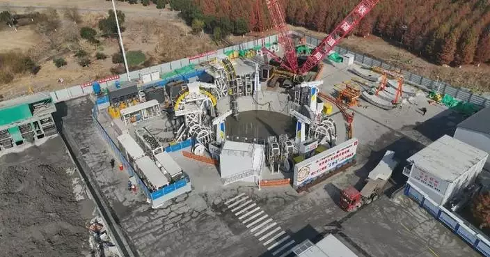
World’s largest-diameter boring machine put into use for Yangtze River railway tunnel
- Nigeria petrol price cuts ease living costs, raise durability concerns
- Chicago expands housing supply to ease affordability pressure
- Turpan City in Xinjiang hit by continuous heavy fog
- Traditional treatments, advanced equipment on China's navy hospital ship wow Brazilian visitors
- Cold wave triggers temperature dips, snowfall in northwest China's Xinjiang
- AI tennis robot serves as perfect practice partner for players in Shenzhen
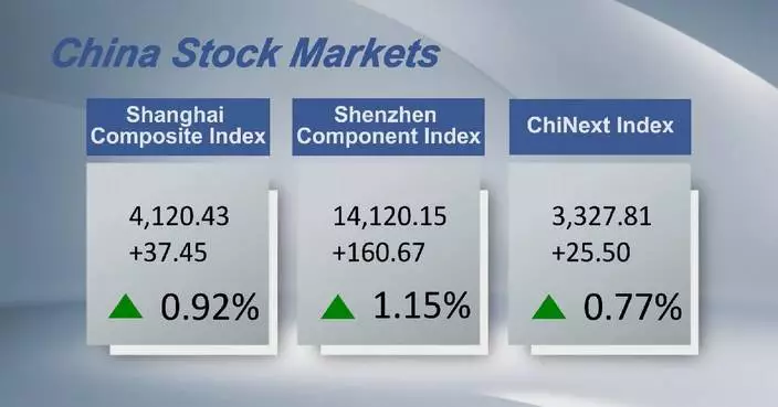
- Chinese shares close lower Tuesday with record single-day A-share trading turnover
- Former Fed chairs, US officials decry criminal probe against Jerome Powell
- Innovative technology breathes new life into centuries-old winter fishing tradition in northeast China's Jilin
Category · News
NYC Council employee’s arrest sparks protests and a dispute over his immigration status

Justice Department sees no basis for civil rights probe in Minnesota ICE shooting, official says
Latvia to make injury replacement for the Olympics with Eriks Mateiko out

Trump calls on Tehran to show protesters humanity amid reports of rising death toll in crackdown

Chloe Kim says she's 'good to go' for Olympics despite labrum tear in shoulder

Semenyo scores again as Man City beats Newcastle 2-0 in English League Cup semifinal

The Latest: Trump lashes out at Federal Reserve in speech to Detroit Economic Club

Manchester United hires former player Michael Carrick as head coach until end of the season

'West Wing' actor Timothy Busfield turns himself in to face child sex abuse charges in New Mexico
NLCS (Singapore) Brings World-Class Musical Opportunities to Young Artists Across Asia

Rio de Janeiro zoo animals are treated to popsicles as the city faces scorching summer weather
China's Long March-8A rocket launches new satellite group

Georgia lawmakers move to strike Savannah ban on guns in unlocked cars

Democrats will spend millions to shift voter registration strategy ahead of the midterm elections

Veracity Launches Metabolic Power Protein: A Smarter Protein Designed to Strengthen Your Metabolism Without Toxicity

National Board of Review to fete 'One Battle After Another.' Here's how to watch stars' arrivals

Wall Street executives warn Trump: Stop attacking the Fed and credit card industry

In New York, Hochul moves to thread needle between Democratic divides ahead of a contested election

Denmark, Greenland leaders stand united against Trump's Greenland takeover call ahead of key meeting
Claudette Colvin, who refused to move seats on a bus at start of civil rights movement, dies at 86

The Latest: Iran eases some communications restrictions as activists say death toll spikes to 2,000

Hospital and nurses fail to negotiate during second day of NYC's largest nursing strike in decades
Death toll from Iranian protests surpasses 2,000, activists say, as chaos recalls 1979 revolution
‘Dances with Wolves’ actor Nathan Chasing Horse's child sex abuse trial begins

Minnesota protesters, agents repeatedly square off while prosecutors quit after Renee Good's death
Chang'e-6 lunar sample unveils key clues to moon's geological evolution

Louisiana seeks California doctor’s extradition, testing the limits of shield laws

Leverkusen's Bundesliga game at Hamburg postponed over stadium roof concerns

Neurosoft Bioelectronics Wins 2026 Startup World Cup Las Vegas Regional Competition
Aptar’s Nasal Vaccine Delivery Solutions Featured in CastleVax Phase II Clinical Trial of an Intranasal COVID-19 Vaccine Candidate

GIGABYTE Redefines Human-AI Interaction at CES 2026 with a Fully Immersive, Participatory Experience

Detroit Auto Show opens as industry pares back splashy debuts and leans on test tracks

Hundreds more Venezuelans come forward to register relatives as 'political prisoners'

Diamondbacks acquire 8-time All-Star 3B Nolan Arenado in a deal with the Cardinals

Trump visits a Ford pickup truck factory, aiming to promote his efforts to boost manufacturing

Nartey's breakthrough goal gives Stuttgart a 3-2 win over Frankfurt in thriller

Mikaela Shiffrin and Lindsey Vonn's US teammates are also making an impact in the Olympic season

Trump administration says it is ending deportation protections for some Somali migrants

Mike Tomlin steps down after 19 seasons as coach of the Pittsburgh Steelers
Attorneys give dueling narratives to open 'au pair affair' double murder trial in Virginia

Gaza's living conditions worsen as strong winds and hypothermia kill 5

Trump administration labels 3 Muslim Brotherhood branches as terrorist organizations

Eagles move on from OC Kevin Patullo after one lackluster season with him calling plays

Wall Street pulls back from its records as JPMorgan Chase and Delta kick off earnings season

Plane used in boat strike off Venezuela was painted to look like a civilian aircraft, AP sources say
Armed Forces Benefit Association (AFBA) Appoints Larry O. Spencer Chair of the Board

Smithsonian faces a deadline to show Trump its plans for exhibits for America's 250th birthday

Costa Rica's security director says plot to assassinate president uncovered

Photos of demonstrators outside the Supreme Court as it considers upholding transgender sports bans
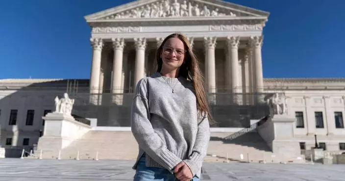
Supreme Court seems likely to uphold state bans on transgender athletes in girls and women's sports

Aubameyang, Manga reinstated after Gabon's post-Africa Cup expulsions, search for coach continues

What to know about the warrants most immigration agents use to make arrests

A suspect in the vandalism of JD Vance’s Ohio home must stay in jail until trial

AFL Introduces Fujikura 100S Fusion Splicer with Dual-Fiber Technology and CT60 Cleaver

New Incisiv Study with Toshiba and Intel Explores How Adaptive Store Operations Balance Experience and Efficiency in Specialty Retail

FACT FOCUS: Trump repeats false claims when discussing Greenland's security in the Arctic
China flu activity declines for fourth week, no new pathogens detected: official
Internet blackout adds to Iran tensions: CGTN correspondent

Immigrant detainee at 'Alligator Alcatraz' agrees to leave US, asks that lawsuit be dismissed

Healthy and rested Rick Bowness ready for next challenge as Blue Jackets head coach

Ex-Navy SEAL convicted of planning to fire explosives at police during San Diego ‘No Kings’ rally

Bears coach Ben Johnson offers no apologies for profane postgame speech

The Steelers are in NFL purgatory. They'll have to find a way out without Mike Tomlin

Creditors Are Leaving Money on the Table—Bankruptcy Accounts Still Hold Value

Next-Generation TFX Thermoformer Sets New Benchmark in Speed and Flexibility for High-Volume Producers
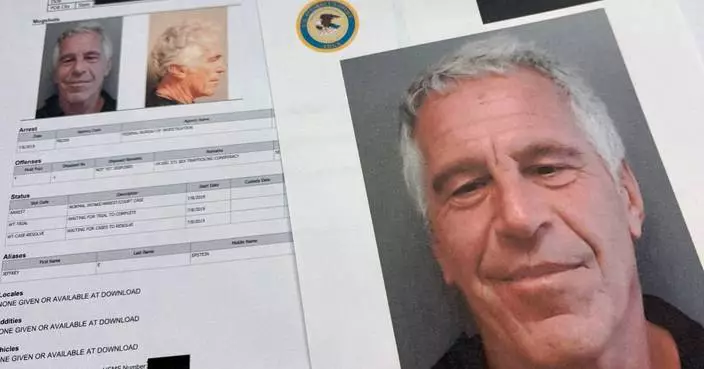
Clintons refuse to testify in House Epstein probe as Republicans threaten contempt proceedings

Bargain grocer Aldi seizes the moment in an era of higher prices

Matt Ryan is seeking to handle unfinished business in his new role as Falcons president of football

EPA proposes limiting power of states and tribes to block major projects over water concerns

Cherished Sierra Club Cabins Now Available to Book on Hipcamp for Winter

Marine Le Pen's appeal trial opens in Paris, with far-right leader's 2027 presidential bid at stake

South Korean prosecutor seeks death sentence for ex-leader Yoon over martial law decree

MGallery Collection Steps Into 2026 With New and Exciting Destinations

TCL Note A1 NXTPAPER Achieves Multiple Awards at CES and Launches Pre-sale, Redefining the E-Note Experience
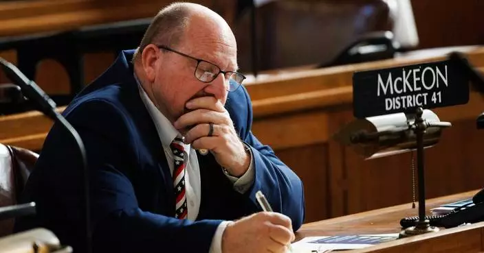
Tearful Nebraska state Sen. McKeon resigns amid accusations of inappropriate behavior

Panthers GM says team will pick up QB Bryce Young's 5th year option, no timeline on extension

NFL's wild-card weekend was full of fourth-down fun and folly along with a dearth of punts

Snoop Dogg's NBA analyst role underscores why his on-air presence and global appeal keeps growing
Chicago among 5 Athletes Unlimited Softball League franchise locations announced for 2026 season

SiriusXM rehires Chris Cuomo to host morning talk show

Syrian army and Kurdish forces exchange strikes in an area near Aleppo
Chinese commerce chambers welcome latest development in China-EU EV talks

Tenneco Goes Live on QAD Adaptive, Accelerating Manufacturing Operations Modernization Across Global Operations

WIRobotics Concludes CES 2026, Advancing into Execution Phase of Global Collaboration Across Humanoid and Wearable Robotics
Feature·Bloggers